U.S. Department of Transportation
Federal Highway Administration
1200 New Jersey Avenue, SE
Washington, DC 20590
202-366-4000
This chapter describes the findings from each site visit. It provides a context for each country's overall approach to congestion management and summarizes key strategies deployed in each country related to traffic management and managed lanes.
The scan team began the scanning study in Athens, Greece, to participate in the First International Symposium on Freeway and Tollway Operations. While this country was not on the list of those visited from the direct perspective of the scan purpose, the group was able to assess some of the congestion management issues in Greece as part of symposium activities. The following sections highlight the observations and findings that pertain to the scan purpose and objective.
Greece is one of the countries in the Balkan Peninsula region of southeastern Europe. It is experiencing significant economic growth and expansion largely as a result of joining the European Union (EU). Along with this growth comes an increase in congestion on the country's roadway network. Most of the roadways across Greece are two-lane undivided roadways providing local access to users. Only recently have projects been undertaken to expand these roadways to increase mobility from both a national and regional perspective.
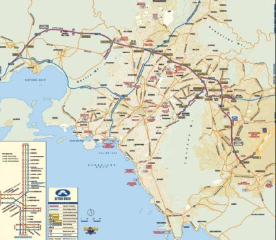
At the national level, Greece has no modern freeway facilities funded completely with public dollars. The government has designated specific corridors on the network as part of the EU Trans-European Transport Networks (TEN-T) program. The corridors are identified as those that play a crucial role in ensuring the free movement of passengers and goods throughout the European Union and achieving balanced economic growth in the member countries.(11) The primary corridors that are part of TENT-T in Greece are the Egnatia Motorway and the Pathé Motorway. As figure 4 shows, they provide critical access to adjacent countries while providing mobility throughout Greece and opening access to all regions of the country. The upgrade of these facilities to limited-access freeways is being funded in large part by private sector investment.
Figure 4: Greek motorways on TEN-T in Athens, Greece.
The Egnatia Motorway, the primary east-west route across Greece from the eastern port of Igoumenitsa to Turkey, links the major cities in northern Greece along with five ports and eight airports and intersects with eight major north-south roadways.(12) This four-lane motorway, which follows a second century route, is mostly complete, with full completion expected by 2008. The Pathé Motorway is the main north-south route through Greece that connects Patras in the south with Thessaloniki in the north and Bulgaria.(12) Mostly complete with four- and six-lane cross sections, the Pathé Motorway will close the missing links between Thessaloniki and Sofia by 2010 and will ensure primary access to other countries in this part of Europe. This motorway also links with the Attiki Odos Toll Motorway, a major ring road around Athens discussed in the next section. Both of these completed roadways will serve as a major national network across Greece and enhance regional and local mobility for all Greeks.
The national trend in transportation finance is the use of public-private partnerships (PPPs). The economic climate is ripe for these types of alternatively financed projects, and Greece has a successful cofinanced venture in the Attiki Odos that serves as an example for future endeavors.(13) An indication of this trend is the seven concession projects under development to extend existing motorways and meet the mobility needs of the country.(14) Critical partners in these projects will be Greek banks and construction companies, who have already proven their commitment to infrastructure expansion.
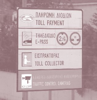
The Attiki Odos Toll Motorway, opened in 2004 before the Summer Olympics, is the first urban freeway in Greece (see figure 5).(15) The facility runs from Elefsina to Markopoulo, providing access to the region around Athens, including the Athens airport.(16) Also known as the Attica Tollway, Attiki Odos significantly aids in reducing congestion in Athens. A major link in the region's mobility, it is connected to the TEN-T motorways in the country. A total of 65 kilometers (km) long, the facility is instrumented with closed-circuit television (CCTV) cameras, dynamic message signs (DMS), lane control signals, and pavement sensors to monitor operations and measure performance. The speed limit is 100 kilometers per hour (km/h) in the sections through the center of Athens and 120 km/h on the outer ends in the suburbs. Electronic toll collection (ETC) is used for nearly 50 percent of all toll transactions during peak hours and 40 percent overall. Toll discounts are offered to frequent users, ranging from 15 percent for habitual commuters to 40 percent for those logging more than 80 transactions a month, such as taxis.
Figure 5: Attiki Odos Toll Motorway in Athens, Greece.
A public-private partnership project (PPP), the Attiki Odos is only the first of numerous motorways to be constructed in Greece. Plans are underway to construct nearly 1,000 km of additional motorways under a number of concession projects, which will enhance connectivity and mobility to critical regions around Athens and across the country.(13) The Ministry of Environment, Physical Planning, and Public Works considers these major corridors, including those designated as TEN-T routes, key to developing a critical and dense network of modern motorways to serve the people of Athens and surrounding regions and to help reduce congestion.(14)
As part of the construction and operation of Egnatia Motorway, the operating agency (Egnatia Odos A.E.) has deployed traffic count collection and processing systems on sections open to traffic.(17) This system, an integrated group of 65 data-collection stations along the motorway, uses inductive loops, microwave sensors, and telemetry software to collect traffic data and send them back to the toll authority's headquarters. These data, along with a traffic forecasting model, are used to predict demand on the transport networks for use in making decisions on motorway design, monitoring and telematic installations, feasibility studies, environmental assessments, maintenance needs, and other planning-related activities associated with the motorway and its intersecting roadways.(17) Similar data collection systems are in place on the Attiki Odos for monitoring operations and performance of the motorway around Athens.
The following sections summarize specific traffic management strategies Greek agencies use to manage congestion on critical roadway networks, including tolling, variable speed limits, and active traffic management.
The primary method used to manage congestion along the Attiki Odos Toll Motorway is tolling. The toll is a flat fee of €2.70 for passenger cars and light commercial vehicles, regardless of the distance traveled on the facility. Rates are lower for motorcycles and higher for larger vehicles. The intent of this flat toll schedule is to discourage short-distance trips.(15) The toll authority that operates the facility, Attikes Diadromes, may consider variable tolling to manage traffic flow in the future if congestion on the facility becomes detrimental to operations.
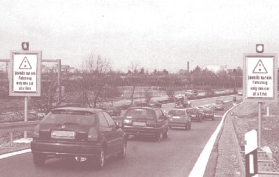
The facility also uses variable speed limits at the entrances to tunnels along the tollway as well as dynamic lane assignment signals (see figure 6). These signs are used to alert motorists if the advisable speed limits inside the tunnel are different from the rest of the facility. Moreover, these signals alert motorists if specific lanes in the tunnel are closed, such as for maintenance or an incident.
Figure 6: Attiki Odos Toll Motorway variable speed limit signing in Athens, Greece.
Congestion at toll plazas is reduced by the use of dedicated lanes for ETC. As figure 7 shows, numerous ETC lanes are provided for customers and advance signing provides clear information to the user of impending toll payment, dedicated lanes, and automated enforcement of tolls at the plaza.
Figure 7: Attiki Odos Toll Plaza (left) and related plaza sign (right) in Athens, Greece.

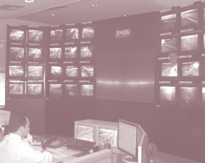
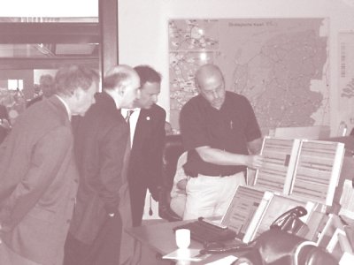
Attikes Diadromes operates a state-of-the-art traffic management center (TMC) for the Attiki Odos (see figure 8). The center operates 24 hours a day, 7 days a week and monitors operations along the facility using the deployed technology noted previously. Operators in the center use dynamic message signs to alert tollway users to real-time travel information, basic safety rules, and special messages on extraordinary traffic conditions, such as an incident.(16)
Figure 8: Attiki Odos Traffic Management Center in Athens, Greece.
A critical component of the active management of the tollway is a comprehensive system for handling incidents, the primary objective of which is to enable quick intervention in incidents while providing high-quality services that ensure optimum traffic conditions. Through a combination of pavement sensors, closed-circuit televisions (CCTV), emergency roadside telephones spaced every 100 meters (m), and patrol units (as shown in figure 9) that operate around the clock, trained personnel at the TMC are alerted to incidents along the roadway. These personnel are critical to the efficient provision of assistance at incidents and the quick remedy of any problem. They maintain constant communication with personnel in the patrol units who serve as first responders and offer assistance at incidents at no charge.
Figure 9: Attiki Odos incident response unit in Athens, Greece.
TMC staff also provides information to road users via dynamic message signs and alert vehicle recovery units, the traffic police department, the ambulance service, and the fire brigade when necessary to clear an incident swiftly. Moreover, the staff coordinates road maintenance and vehicle cleaning activities to ensure that they do not negatively impact operations and that the appropriate specialized vehicles and personnel are deployed for each incident. Duties of incident management partners are clearly defined in manuals and formal agreements to ensure a clear chain of command and swift response and removal.
The Egnatia Odos facility also has a complex incident management strategy with a four-step process of detection, verification, response, and clearance. The TMC for the facility uses technologies similar to those used on the Attiki Odos and is responsible for traffic data collection, traffic management, weather information dissemination, emergency management, and provision of travel information to users.(18) Critical partners in the incident management structure include emergency crews, highway assistance, fire brigades, police, and ambulance services.
Managed lane-related operational strategies have been deployed primarily on Greek arterials because Greece did not have any urban freeways until 2004. To date, these freeway facilities are not congested and are not identified as needing managed lanes to help manage congestion. The following sections summarize the two types of managed lane strategies that have been implemented on arterials in Athens.
One managed lane operational strategy of note in Greece is bus lanes that are operational in Athens and expanding outside the city center.(15) Bus lanes operate on about 50 km of roadways in the city. They operate as exclusive bus lanes on weekdays from 6 a.m. to 9 p.m. and on Saturday from 6 a.m. to 4 p.m., with no restrictions on Sundays.(15)
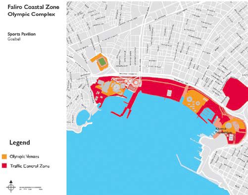
During the 2004 Olympic Games in Athens, various managed lanes were established on the urban street network to facilitate transport to and from the various venues in the Olympic cities. Called Olympic Lanes, these lanes were for the exclusive use of Olympic athletes, VIPs, accredited media, sponsors, technical officials, public transport buses carrying spectators, and Olympic-accredited vehicles.(15) The restrictions on these lanes, which were on arterial streets, were from 6:30 a.m. to midnight during the 17-day Olympic Games.(19) Special traffic arrangements were also implemented during the companion Paralympic Games in Athens September 15 to 30, 2004. These included traffic control zones (TCZs) where access and circulation were modified to allow access to specific venues to authorized vehicles only.(20) Figure 10 shows an example of the TCZs around the Faliro Coastal Zone Olympic Complex.
Figure 10: Faliro Coastal Zone Olympic Complex in Athens, Greece.
With the exception of the bus lanes and Olympic lanes, no additional managed lane strategies operate in Greece and the transportation authorities have no plans to implement any in the foreseeable future. However, managed lane facilities may be needed as congestion increases on the expanding freeway network.
The German federal motorway network is about 12,000 km across 10 states—mostly four- and six-lane facilities—carrying an average daily traffic (ADT) of about 49,000 vehicles.(21) These federal roads carry about one third of all of the traffic across the country, yet are only a small percentage of the entire German roadway network. Since the removal of the Iron Curtain and reunification of Germany, demand on the network has increased and is expected to increase an additional 16 percent for passenger transport and 58 percent for freight transport by 2015.(21) The federal government owns the federal motorways and highways and finances their construction, maintenance, and telematic infrastructure deployment, while the individual states are responsible for maintenance, operations, traffic safety, traffic regulations, and financing the planning and operational activities for the network.(22)
In response to this growing demand, the Federal Ministry of Transport, Building, and Urban Affairs established a Federal Transport Infrastructure Plan to upgrade the road network by 2015 through major construction projects. This plan includes constructing 1,730 km of new motorways, widening 2,162 km of existing motorways, and constructing 717 bypasses across the country.(21) In addition, the ministry has a comprehensive 5-year Programme for Traffic Control on Federal Motorways, which is geared toward overall management of the federal motorway network. This program's objectives are to (1) increase by 1,200 km the length of motorways equipped with traffic control systems, (2) increase by 2,400 km the length of motorways with dynamic diversion possibilities, and (3) increase by 15 the number of traffic control centers across the country. Both federal initiatives illustrate a national movement to upgrade and actively manage the motorway network for efficient operations and to enhance the mobility of the country's citizens.
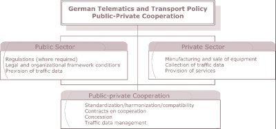
The German federal government also has a policy on telematics and transport, with a primary emphasis on public-private cooperation. The intent is to define specific responsibilities that are best handled by the public sector, those that are best handled by the private sector, and those that can best be accomplished by public-private partnerships. This policy, shown in figure 11, recognizes the strengths of the private sector in some arenas and acknowledges that some activities can be undertaken only by governmental agencies and should remain under public control.
Figure 11: German public-private cooperation policy.
At the regional level, German states establish freeway operation programs for their motorway networks with two primary objectives. The first objective is to maintain or increase safety by harmonizing traffic flow, providing hazard warnings to motorists, and providing dynamic in-vehicle information on traffic conditions to users.(22) The second objective is to maintain and improve mobility, which is achieved through the optimal use of the existing network capacity and the use of various operational strategies to temporarily increase road capacity.(22)
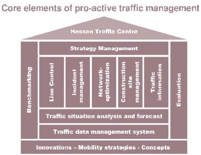
Traffic Center Hessen has established a proactive traffic management approach, illustrated in figure 12. This approach is a comprehensive framework that encompasses benchmarking of network performance; deploys and maintains various traffic management strategies to meet the aforementioned objectives; incorporates data management, traffic analysis, and forecasting to evaluate and assess the impacts of those strategies; and facilitates the implementation of innovations to enhance mobility. The various traffic management strategies employed to manage congestion are discussed later in this section.
Figure 12: Elements of proactive traffic management in Hessen, Germany.
This proactive traffic management program is part of a larger initiative called "Staufreies Hessen 2015" ("Congestion-Free Hessen 2015"). Other regional administrations have similar programs under development, and the intent of the Hessen program is to no longer have Hessen in the traffic-related media by the target year.(23) The primary focus of the plan is on the technical aspects of managing congestion and addressing safety needs. However, the strategic planning of roads is not included in this initiative, and the states must compete for federal funds for such programs.(23) The scan team did not identify any regional plans to address future expansion of the freeway network.
The motorways across Germany outfitted with traffic control systems gather traffic data from such technologies as inductive loop detectors, floating cars, video cameras, and other sensors deployed along the facility.(22) This data is critical to the successful and efficient management of the roadway network and the management of congestion on critical segments. Field data processed at the regional traffic management center is used to determine such performance measures as traffic flow, speed, headways, level of service, travel time estimation, and percentage of trucks in the traffic stream. This data is also used to estimate congestion levels and predict performance.(22)
The Germans have a long history of providing traveler information to motorists. Traditionally, agencies have used public broadcast methods and law enforcement to alert roadway users to incidents, congested conditions, and other events or situations that may impact operations. Traffic management centers now play a critical role in this communication strategy. A primary use of the traffic data gathered by TMCs is to provide traveler information to users and actively manage congestion on the network. Operating agencies firmly believe in the need to gain the trust of users so that they will comply with changes in speed, lane use, and route guidance information. Thus, they provide accurate and reliable information that does not adversely impact the roadway user. All of these efforts support the federal goal to have 80 percent of all trips on the motorway network adequately served by standardized real-time traffic and traveler information (RTTI) by 2010.(21)
The following sections summarize specific strategies undertaken by agencies in Germany to manage congestion on critical roadway networks. The strategies include speed harmonization, queue warning, temporary shoulder use, junction control, construction site management, truck restrictions, ramp metering, heavy goods distance-based tolling, and traffic and traveler information.
Speed harmonization has been used in Germany since the 1970s and is geared toward improving traffic flow based on prevailing conditions. Known locally as line control, speed harmonization is deployed on motorway sections with high traffic volumes. The speed harmonization system in the Rhine-Main area, which is monitored from Traffic Center Hessen shown in figure 13, monitors traffic volumes and weather conditions along the roadway. If sudden disturbances occur in the traffic flow, the system modifies the speed limits accordingly, providing users with the quickest possible warning that roadway conditions are changing.(24) The Germans have found success with speed harmonization on their motorways. For example, when implemented on the A5 between Bad Homburg and Frankfurt/West, speed harmonization was attributed with a 3 percent reduction in crashes with light property damage, a 27 percent reduction in crashes with heavy material damage, and a 30 percent reduction in personal injury crashes.(22)
Figure 13: Speed harmonization at Traffic Center Hessen in Germany.

Modeling and freeway simulation are also important to the overall management of congestion in Germany. Like other countries, Germany uses the microscope traffic simulation program VISSIM to assess the impact of operational changes to the roadway network. This behavior-based multipurpose program is extremely useful for optimizing complex technical systems in the laboratory before they are implemented in the field.(25) To support the speed harmonization strategies common to motorways in Germany, the German-based company that developed VISSIM wrote the software code so that the simulation package interfaces with the speed harmonization systems. Thus, the software incorporates the different thresholds for the deployment of speed harmonization and handles speed distributions across all lanes.(26) This tool has proven to be extremely useful in assessing the overall impacts of speed harmonization and other congestion management strategies on motorway operations.
A major addition to the speed harmonization system in Germany is its queue warning system. Integrated with the active management gantries, this system involves displaying a congestion pictograph on each side of the speed harmonization gantry indicating congestion ahead, as shown in figure 14. In other installations, this congestion pictograph is displayed on an overhead DMS. This warning system is intended to help reduce the occurrence of secondary incidents caused by either recurrent or nonrecurrent congestion. Gantries are generally spaced 1 km apart, and the system typically begins reducing speeds between three and four gantries before an incident.(23)
Figure 14: Congestion warning system in Germany.
The first installation of the queue warning system was on the Motorway A8 between Stuttgart and Ulm. Positive results from the pilot included fewer incidents, reduced incident severity, a considerable reduction in higher travel speeds combined with a strong harmonization of all driving speeds, closer headways, more uniform driver behavior, a slight increase in capacity, and overall safer driving because of motorists' awareness of oncoming risks and their tendency to approach the back of a queue with care.(21) The result of this successful pilot has been broader implementation of the queue warning system across the country and the inclusion of this strategy in the overall approach to managing congestion.
Temporary shoulder use is a congestion management strategy typically deployed in conjunction with speed harmonization to address capacity bottlenecks on the freeway network. The strategy, known in Germany as temporary hard shoulder use, provides additional capacity during times of congestion and reduced travel speeds. Germany has used the right shoulder as a driving lane during peak travel periods since the 1990s, with the first deployment on the A4 near Cologne in December 1996.(27) Today, nearly 200 km of temporary shoulder are in operation around the country. This temporary shoulder use is one of several traffic control systems developed by the Federal Ministry of Transport and used in various locations in the country.(28) When travel speeds are reduced, signs indicate that travel on the shoulder is permitted, as figure 15 shows. This installation is located on the Autobahndirektion Südbayern (South Bavaria) and has had the official signs added digitally for illustrative purposes. Figure 16 shows the complete series of signs indicating operations related to temporary shoulder use, including one with a supplemental speed limit indication (used when overhead gantries are not present). These signs and the overhead lane messages are blank when travel on the shoulder is not permitted. Temporary shoulder use is permitted only when speed harmonization is active and speed limits are reduced. Other components typically installed with the required regulatory signs include overhead gantries with speed limit displays, dynamic direction signing, video cameras, and connection to the traffic management center for deployment and monitoring.
Figure 15: Right shoulder use with speed harmonization in Germany.
Figure 16: Temporary shoulder use regulatory signs in Germany.

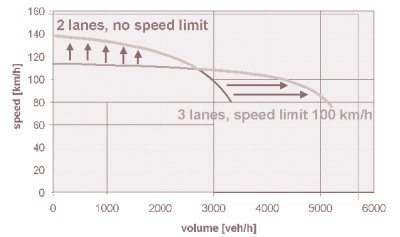
As to be expected, traffic management centers play an integral part in implementing temporary shoulder use. CCTVs are used to ensure that disabled vehicles are not blocking shoulders. Their deployment is closely tied to the speed harmonization system and the relevant data are gathered to implement that strategy. Generally, implementation of temporary shoulder use is at the discretion of the TMC operator, although traffic volumes help determine the need for the strategy.(23)(23) Overall, temporary shoulder use affords congested motorways with higher throughput, as shown in figure 17. The addition of the third lane in the form of temporary shoulder use, while slightly decreasing speed and initially reducing volumes on the motorway, actually delays the onset of congestion and breakdown and increases the overall throughput on the facility.
Figure 17: Speed-volume relationship of temporary shoulder use in Germany.
This strategy is not without drawbacks, including installation, maintenance, traffic safety, and incident costs. Thus, the Federal Highway Research Institute (BASt) in Germany developed a software tool to conduct an economic assessment of the implementation of hard shoulder use (either temporary or permanent) on congested motorways.(29) This software tool has a general framework that measures the various costs and benefits of temporary right-shoulder use to determine project viability and economic effectiveness. These costs include capital investment, maintenance, traffic safety and incidents, speeds and travel time, and emissions.(29) The software can assess numerous temporary shoulder-use applications at once to help the user identify the most effective locations for implementation. Once the user inputs the various data the software requires, the tool weighs costs against positive impacts to arrive at a benefit-cost ratio for each potential application. In each run, the program calculates the benefit-cost ratio for one location and different implementation strategies (i.e., permanent, temporary, and with speed harmonization). The implementing agency can then select for implementation the locations that have the best benefit-cost ratio and represent the best investment of limited resources.
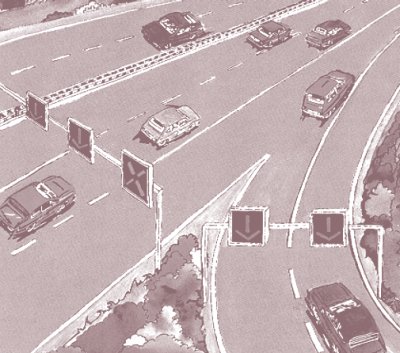
A variation of the temporary shoulder use in Germany is junction control, a combination of ramp metering and lane control at on-ramps.(30) Typically, the concept is applied at entrance ramps or merge points where the number of downstream lanes is fewer than upstream lanes. The typical U.S. application to this geometric condition would be a lane drop for one of the outside lanes or a merge of two inside lanes, both of which are static treatments.(28) The German dynamic solution is to install lane control signals over both upstream approaches before the merge (shown in figure 18), and provide priority to the facility with the higher volume and give a lane drop to the lesser volume roadway or approach.(28)
Figure 18: Junction control schematic in Germany.
Transportation agencies and maintenance centers across Germany have at their disposal a construction site management tool for motorways. The intent of this computer software is to assess the impacts of short-term construction projects on congestion and allow for the optimization of timing for such efforts.(23) As depicted in figure 19, the tool identifies the level and duration of major congestion impacts resulting from short-term work zone projects based on traffic volumes from a typical day. It easily allows the user to compare start times for a project and minimize congestion impacts by moving construction to a less critical time of the day. Although most construction is not performed at night because of safety issues, some projects are scheduled for nighttime hours if their daytime impacts on congestion and operations are too severe. While most of these maintenance-related projects are undertaken by outside contractors, some maintenance is done by internal personnel. Despite the obvious benefits of using the construction site management tool, maintenance centers are not required to use it, so there is not much motivation for them to alter their typical schedules for projects.
Figure 19: Road works management tool.
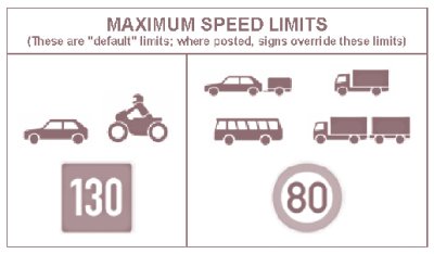
In Germany, most heavy vehicles have considerably lower speed limits than automobiles, such as those shown in figure 20 for the Autobahn roadways. In addition, trucks are often restricted to the rightmost lane across Germany (as well as many other European countries), which is mostly a practical matter when combined with lower speed limits and typical four-lane expressway cross sections.(31)
Figure 20: Autobahn speed limits.
Specific operating behavior is also required of trucks on motorways under the control of speed harmonization. For example, when speed harmonization is not in effect, heavy vehicles may use any lane of a motorway. However, under speed harmonization, they must use only the right lane and are not allowed to pass slower heavy vehicles using the same lane.(23) When drivers see speed harmonization signs on gantries, they automatically know that these restrictions are in effect and act accordingly. The average truck traffic on most motorways is between 10 and 12 percent.(23)
Ramp metering is fairly new in Germany. Because geometric constraints on both freeways and surface streets provide limited storage, applications are limited as a whole. The concept was first tested in 1999 in five pilot projects on the A40, yielding positive results. In the pilot project, congestion decreased more than 50 percent during peak periods and traffic incidents at the ramps decreased 40 percent.(33) Also, average speeds on the A40 increased by more than 10 km/h during peak travel periods. As a result of these successful tests, more ramp metering systems are being installed across the country.
The typical operation, shown in figure 21, is initiated when ramp demand exceeds 1,000 vehicles per hour. The systems run constantly during peak periods and allow no more than two vehicles per cycle to ensure the dispersion of platoons in the entering traffic.(33) Originally, static signs were placed at the signal to indicate how many vehicles were to enter on one cycle. However, the dynamic signs shown in figure 21 were installed to eliminate user confusion and to allow changes in the number of vehicles per cycle based on current traffic conditions.(33) Some systems in place, however, have had nearly no effect on operations, while some that allow only one vehicle per cycle still experience congestion.
Figure 21: Ramp metering in Germany.
As discussed previously, Germany has a national goal to adequately serve 80 percent of all trips on the motorway network by standardized real-time traffic and traveler information (RTTI) by 2010.(21) A critical component of this goal is the use of advanced technologies to provide dynamic rerouting information to users. As figure 22 shows, Germany installs rotational prism guide signs that change with traffic conditions. If an incident occurs along a facility, operators at the TMC deploy alternate guide sign information combinations that provide alternate route information to roadway users. Similar information is also provided on full-matrix DMS installed on other roadways, as shown in figure 23. On facilities that employ speed harmonization combined with temporary shoulder use, the signs change so that the information displayed for the operational lanes is appropriate.
Figure 22: Dynamic rerouting in Germany.
Figure 23: Rerouting information on a dynamic message sign in Germany.
Germany also has initiated a concerted effort to standardize messages on dynamic message signs to reduce the likelihood of motorist confusion. As international traffic grows on the German motorway network, officials believe that some foreign users may not perceive the information displayed on DMS appropriately.(21) Used only for traffic-related purposes, German DMS display messages follow a set of basic principles to ensure comprehension by the most users:
Graphics and pictograms are used to replace text whenever possible, and any text that does appear is to be as unambiguous as possible to minimize confusion.
Another component of the RTTI system is the traffic message channel. This information channel provides traffic-related messages to motorists via onboard Global Positioning System (GPS) units that can decode them into preferred languages. Most messages are generated from detection systems in the field and are repeated every 2 to 3 minutes to ensure their quick receipt on the roadway.(21) A variety of providers make the factory-installed or aftermarket onboard units available and are working toward significant penetration in the vehicle fleet across the country.(21) Providers include broadcasters, the automobile and radio industries, law enforcement and other authorities, and private information suppliers such as auto clubs. Nearly 5 million units are already in use and their cost is decreasing.
RTTI transmitted via public radio is considered a major tool for traffic managers. Since traffic broadcasts began in the early 1960s, the number of traffic messages has increased considerably as a consequence of increased traffic loads and congestion. While in the beginning traffic messages were in the form of spoken messages, which meant a lot of interruptions of the running radio program, a new way to convey information to drivers is to transmit digitally encoded messages on FM frequencies in a side-band, the so-called Radio Data System (RDS). The Traffic Message Channel of the Radio Data System (RDS-TMC) has been operational since 1997. Main components of digitally encoded traffic messages are location codes and event codes, based on European Committee for Standardization (CEN) and International Organization for Standardization (ISO) standards. In Germany today, RDS-TMC messages are transmitted without program interruptions on roughly 50 radio program chains.
These digitally encoded traffic messages are used in in-vehicle navigation systems, which decode the messages to improve route calculations. This enables road operators to include routes not equipped with variable direction signs or variable message signs in their management schemes. The introduction of RDS-TMC has encouraged electronic and car manufacturers to design and market new navigation devices.
It is a traffic policy objective to enable free access to safety-related traffic messages. Therefore, no subscription fees are charged for RDS-TMC information. Besides these free services offered mainly by public radio stations, commercial service providers offer encrypted TMC information by subscription.
The operation of a digitally encoded information channel has enabled traffic managers to automatically include information from roadside traffic detectors in the information chain. Typically, 2 to 5 minutes are needed to provide information about congestion.
The success of RDS-TMC in Europe and especially in Germany has contributed to its worldwide application, including in the United States, Australia, and Singapore. Efforts are underway to use digital transmission channels such as digital multimedia broadcasting (DMB) in the future to provide a higher transmission capacity so that local and urban information can also be included.
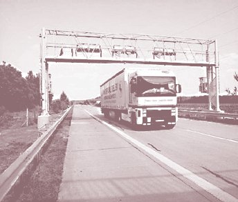
Since the formation of the European Union, truck traffic has increased significantly on Germany's motorway network, much of it passthrough traffic headed to other EU countries. The increased use of the network increases maintenance costs. Thus, Germany implemented heavy goods vehicle tolling on its motorways in 2006 to accomplish several objectives, one of which was to guarantee the financing of new roads and maintenance of the entire network.(34) Other motivations for this electronic toll system, shown in figure 24, are to create a pricing scheme borne by the originators of road demand, create an incentive to change the modal split for freight, enhance the efficient use of trucks, and promote implementation of innovative technology.(34)
Figure 24: Distance-based heavy goods vehicle tolling in Germany.
Operational strategies that would be classified as managed lanes according to the U.S. definition include speed harmonization combined with temporary shoulder use and truck restrictions. This actively managed approach works to increase throughput under congested conditions and optimizes the use of the existing infrastructure based on current conditions.
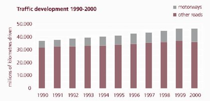
Traffic and congestion are increasing in Denmark as they are elsewhere in Europe. Figure 25 shows that traffic volumes grew significantly on motorways and other roads across the country in the 1990s, and traffic is expected to grow at an average annual rate of 1.7 percent through 2010, putting ever-growing demand on the roadway network.(35) As in other countries in Europe, a growing percentage of this mileage increase is on major trunk roads and motorways, and the potential of expanding the network with additional major roads is not realistic. Thus, the current network must be used effectively and efficiently to ensure future mobility.
Figure 25: Traffic growth in 1990s in Denmark.
The national vision for transportation in Denmark is to work collaboratively with all other players to provide a network that benefits all.(37) Potential partners include regional and local authorities, traffic companies, organizations, and industries across the country. This collaborative approach is especially critical with the Danish government's decision in 2002 to merge the existing 13 counties and 172 municipalities into some 100 larger municipalities.(38) Removing a level of government works to eliminate complexities in the roles and responsibilities of agencies, but emphasizes the need for support and cooperation from all parties to ensure successful management of transportation.
Overall, the Danish Road Directorate acknowledges that planning for the future requires adequate and detailed information about the status of transportation and traffic on the existing network. From the perspective of traffic planning and congestion management, the Road Directorate has three main thrusts to ensure mobility for all citizens, all of which are supported by the information it gathers on the existing network. First, sustainability of the transportation network is critical for future mobility. The Road Directorate makes data and analysis results available to researchers and the public to help ensure that tools developed to improve transportation do so in a sustainable manner.(37) Accessibility is a primary factor in mobility. As such, the Road Directorate is developing and deploying congestion management strategies to optimize the use of the existing road network.(37) Finally, the Road Directorate uses large-scale decisionmaking tools and econometric models to assess the impact of transportation measures on society for such factors as travel time, energy consumption, cost, and safety.(37) These tools are available to all collaborative partners and stakeholders in the transportation arena so that all can benefit from their power and knowledge.
Another national initiative that supports transportation network management is the Road Sector Information System (VIS). This national database contains data for all national and regional roads on such items as roads, bridges, pavements, traffic, and incidents.(37) Incident data for local roads are also included, and both the Road Directorate and the regional authorities own the database. The database is linked to other systems to generate traffic analyses, analyze incidents, and illustrate congestion growth on the network. This tool has been useful in identifying bottlenecks and high-incident locations on the network to target improvements. As a result of VIS, incidents have dropped 50 percent during a period when traffic volumes have doubled.(37)
The national approach to traffic management is mirrored at the regional level. By the end of 2006, the Road Directorate was scheduled to open an additional six regional road centers to monitor and support the future motorway network in the country.(38) The six centers will take over the responsibilities that the counties used to perform and will continue to support the cooperative and collaborative approach to transportation management for the country.
The Road Directorate has also deployed intelligent transportation systems (ITS) in major regions to monitor the presence and development of congestion and to inform road users of traffic conditions. The data is part of that gathered by the Traffic Information Center (TIC). In addition, the Road Directorate has developed the TRIM system, which gathers traffic data and provides information to users on traffic conditions on 100 km of roads in the Copenhagen area.(36) One unique aspect of TRIM is that the Road Directorate continuously records the traffic data. These recordings are available on the Internet (www.traffiken.dk) in the form of the TRIM Player, where users can play back recordings and get a feel for the growth of congestion on a particular roadway.(36)
Within a corridor, the Road Directorate has as a policy to minimize the impact construction will have on the local roadway network. The agency's policy is to keep as much traffic as possible on the motorways through a work zone and not divert to the local road system.(39) Essentially, adding vehicles to the local road system and having a diverse vehicle mix on these smaller roads is undesirable and unpopular with local residents. Efforts such as maintaining the same number of through lanes, minimizing complete road closures, and working to share information with local stakeholders work to minimize this route diversion.(39)
The Danish Road Directorate places a high priority on communicating with the road user about traffic conditions. The TIC and open cooperation with all partners help ensure that users have current information about routes so they can make informed choices about their trips. Furthermore, on major reconstruction projects communication is seen as critical to project success and customer satisfaction. For example, the M3 reconstruction project through Copenhagen has several full-time staff members whose only responsibility is public relations with employers and residents in areas served and impacted by the motorway.(39) Also, as discussed in the previous sections, the Road Directorate uses traffic data from VIS in modeling to identify bottlenecks and predict traffic conditions for use in planning efforts and potential system improvements.(40)
The following sections summarize specific traffic management strategies undertaken by agencies in Denmark to manage congestion on critical roadway networks. Those strategies include speed harmonization, truck restrictions, and traveler information.
The M3 Motorway around Copenhagen serves as an excellent example of the use of speed harmonization, also known as variable speed limits, to manage congestion during a construction project. The Road Directorate of the Danish Ministry of Transport and Energy decided to deploy speed harmonization as part of work zone traffic management strategies for the multiyear widening of the M3. Using traffic detection systems, CCTV cameras, and DMS, control center staff in the region monitor traffic and reduce speeds when congestion begins to build.
This active management strategy has been deemed a success by Road Directorate and project staff. As a result of the speed harmonization shown in figure 26, incidents on the motorway have not increased during the reconstruction project, while the existing two lanes have been maintained at a narrower-than-normal width and no entrance ramps, exit ramps, or bridges have been closed.(39) Furthermore, the equipment used to implement speed harmonization will be a permanent installation on the completed facility, which is being constructed with the expectation that the right shoulder will be used as a temporary lane when congestion warrants it in the future.
Figure 26: Speed harmonization in Copenhagen, Denmark.
Since 2005, heavy trucks, buses, and vehicles towing trailers have been prohibited from passing on certain stretches of the Danish motorways.(41) These restrictions were originally implemented on a trial basis to improve traffic flow along with reduced travel speeds for the same vehicles. Reduced speed limits for these vehicles are 50 km/h in urban areas, 70 km/h in rural areas, and 80 km/h on motorways across the country, compared with 50 km/h, 80 km/h, and 130 km/h for passenger vehicles and motorcycles in the same areas.(41)
In response to the growing traffic demands on the country's road network, the Road Directorate established the Traffic Information Center (TIC), shown in figure 27. The center's mission is to improve the use of the country's roadway capacity by creating an intelligent road where users can get relevant information about the roadway network at any time.(35) The center is responsible for providing traffic information about Denmark and supporting emergency preparedness for the national roadway network.
Figure 27: Traffic Information Center in Copenhagen, Denmark.
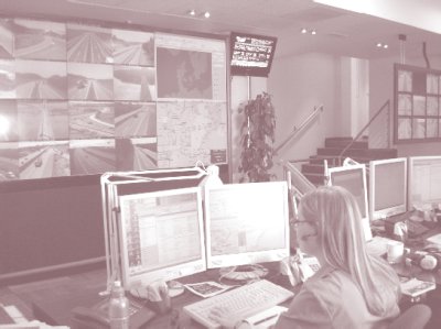
Initially established in 1982 as a cooperative effort with private company Falck A/S to provide traffic reports on morning radio news programs, the TIC operates 24 hours a day, 7 days a week and gathers reliable traffic-related data (e.g., volumes, speed, wind, air, road-surface temperature) from such providers as law enforcement, counties, municipalities, private citizens, private companies, transportation agencies, traffic reporters, road sensors, monitoring cameras, weather stations, and Road Directorate offices.(35) Because of the size of Denmark, the TIC serves as the traffic management center for the entire country as well as the focal point for incident management.(42) The TIC disseminates information to various outlets to ensure the broadest reach to potential users. While these data are useful for many purposes, the primary objective is to improve safety on Danish roads.(35)
To date, no managed lane strategies as categorized by the United States are in operation in Denmark. However, the current expansion project on the M3 includes fully paved shoulders that can accommodate temporary shoulder use when warranted by future congestion. The presence of speed harmonization and connection with the TIC in this corridor will enable this operational strategy to be used with little to no modification when the Road Directorate decides to implement it.
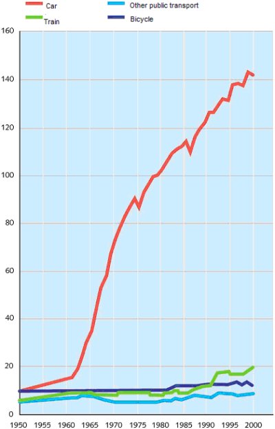
The Netherlands is a country with 16.2 million inhabitants, 6.9 million cars, and more than 250 million vehicle-kilometers each day across its entire roadway network.(43) The Ministry of Transport, Public Works, and Water Management (Rijkswaterstaat) manages 3,250 km of main roads, 1,000 km of which are motorways, and operates one National Traffic Control Center (NTCC) and five regional traffic control centers.(44) As in the rest of Europe, the transportation network in the Netherlands is experiencing increasing congestion and delay. Figure 28 illustrates this growth over the past 50 years, with a continuing a trend of about 3 percent a year, and shows the critical need for congestion management.
Figure 28: Fifty years of traffic growth by mode in the Netherlands.
The federal government in the Netherlands recognizes the connection between transportation mobility and economic strength. Rijkswaterstaat has two traffic-related core tasks: ensure safe and unimpeded movement of traffic and construct, manage, and maintain the main roads and waterways.(44) It has developed a mobility policy that governs all transportation-related activities to focus on customer service and trip reliability. This approach to mobility involves five primary activities:
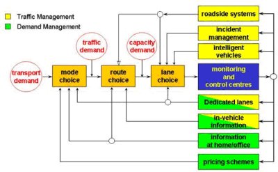
The specific customer service and reliable trip benchmarks used to measure traffic management strategies are to have (1) 95 percent of all trips arrive on time, (2) trips in urban areas take no longer than twice the time it takes during uncongested conditions, and (3) trips on other roads take no longer than 1.5 times that during uncongested conditions.(44) Essentially, all of the efforts undertaken to improve use of the existing roadway through traffic management work to meet these trip reliability goals. All efforts for traffic management comprise a major control scheme, shown in figure 29, that addresses traffic management and demand management. The specific traffic management strategies are discussed later in this section.
Figure 29: Traffic management as a control scheme in the Netherlands.
At the national level, modeling for planning purposes is used to evaluate policy options to identify the most cost-effective use of limited resources. The National Model System for Traffic and Transport (LMS) is a strategic model designed to make forecasts of mobility on the main roadway network across the country.(46) This four-step model has been used for the past 20 years to prepare all transportation policy documents. It assesses the impacts of a comprehensive infrastructure building program, but does not give results specific to roadway sections.(46) Also, it takes goods transport into account, but does not calculate freight volumes.
The New Regional Model (NRM) is used to generate traffic forecasts to provide a better understanding of the information needed to develop regional transport policy. Based on the same philosophy as LMS, NRM provides regional mobility information and is used for planning purposes for policy decisions and the impact of projects at the regional level.(46) Unlike LMS, it can forecast traffic on national trunk roads and major connections, but the results for inner urban roads are not as reliable.
The ministry has also developed two powerful tools that regions use to assess traffic management efforts in their jurisdictions. Shown in figure 30, the Sustainable Traffic Management Handbook is a guide for regional and local road authorities to determine how best to address accessibility problems.(47) The handbook takes the planner through nine steps—from project initiation to completion—to address specific mobility and accessibility needs in a region. The process helps the user develop a network vision based on the policy objectives for the ministry and the region.(47)
Figure 30: Sustainable Traffic Management Handbook used in the Netherlands.
The second tool regional authorities use is the Regional Traffic Management Explorer (see figure 31), a sketch planning and modeling tool that facilitates sustainable traffic management by quantifying benefits of traffic management strategies.(43) It allows the user to compare different scenarios to identify the most effective strategies based on the policy objectives built into the tool on accessibility, safety, and livability. It provides the impacts of operational strategies and system improvements based on such factors as travel time and delay, speed, and traffic volumes on origin-destination pairs, routes, and road sections.(43) Development of the tool was begun in 2003 and the first version was available for general use by late 2004.
Figure 31: Regional Traffic Management Explorer used in the Netherlands.
In the Netherlands' national approach to congestion management, information is a primary resource in the overall traffic management architecture. As figure 29 illustrates, information is the backbone behind all traffic and demand management strategies in the control scheme. The National Traffic Control Center (NTCC), shown in figure 32, coordinates the activities of and gathers traffic-related data from the five regional traffic control centers that center on major cities and operate 24 hours a day, 7 days a week. The NTCC, which also operates 24-7, is the focal point for national traffic operations. It establishes national guidelines and procedures on traffic management, coordinates emergencies, communicates with other European national centers, and collects management information from around the country.(48) Traveler information is disseminated to roadway users via radio, television, electronic messaging, on the roadside, inside the vehicle, and via the Internet. The NTCC fosters cooperation between the national and regional governments to direct road users for optimal roadway performance.(48)
Figure 32: National Traffic Control Center in Utrecht, Netherlands.
The power of the NTCC is also in its gathering of data from the regional centers. The data it collects from various sources are used to support the planning and management activities of the ministry. This assessment of system performance is critical to identifying the benefits of various congestion management strategies and their potential for implementation in problem locations.
The following sections summarize specific strategies undertaken by agencies in the Netherlands to manage congestion on critical roadway networks. The strategies include speed harmonization, queue warning, temporary shoulder use, dynamic lane marking, truck restrictions, ramp metering, dynamic rerouting, tidal flow lanes, truck lanes, and automated speed enforcement.
In the Netherlands, travelers are alerted to congestion and queues by flashing lights and speed signs activated on variable speed limit signs, as seen in figure 33. This warning system, with lane control and speed limit signs generally every 500 m, was first deployed in 1981 and is also referred to as a motorway control and signaling system (MCSS). It is intended to help reduce the occurrence of secondary incidents caused by either recurrent or nonrecurrent congestion. It is deployed to indicate lane closures near incidents and work zones, and to provide queue tail warning and protection in known bottleneck locations.(45) To date, nearly 1,000 km of queue warning systems have been installed, with another 61 km planned for additional motorways across the country.
Figure 33: Congestion warning system in the Netherlands.
The standard speed limit is 120 km/h on the motorways, but posted speeds can drop to 90 km/h, 70 km/h, or as low as 50 km/h if a shock wave or speed drop is detected. These conditions are normally due to high volumes or incidents and incidents occurring on the facility.
The primary functions of the signaling systems are to provide a service to road users and to close lanes for incidents or construction as needed. The Dutch have seen definite benefits from their congestion warning system. As a result of implementation, throughput on facilities in the system increased between 4 and 5 percent, and safety assessments in 1983 and 1996 revealed an increase in traffic stream stability, a 15 to 25 percent decrease in primary incidents, and a 40 to 50 percent decrease in secondary incidents as a result of implementation.(45)
The Netherlands has used speed harmonization for many years. Some deployments have been implemented to promote safer driving during adverse weather conditions (such as fog), while others have been used to create more uniform speeds. Most recently, the Netherlands' MCSS, shown in the two right lanes of figure 34, has been used to reduce speed in a densely populated and environmentally sensitive area to reduce polluting elements. The posted speed limit of 80 km/h is further effectuated by an automated speed enforcement system, which measures average speed over a section of the highway, normally 2 to 3 km long. The system has reduced collisions by about 16 percent, increased throughput 3 to 5 percent, and reduced the cost of work zone traffic control.(45)
Figure 34: Speed harmonization in the Netherlands.
The Netherlands implemented temporary right shoulder use—also known as hard shoulder running or the rush hour lane—in 2003 as part of a larger program to improve use of the existing infrastructure. As figure 35 shows, a gantry with lane control signals indicates when the shoulder is available for use. Where a rush hour lane passes through a junction and at the end of a hard shoulder running section, guidance information changes according to lane use.(49) Assessment of this strategy reveals that implementing temporary shoulder use has increased overall capacity 7 to 22 percent (depending on usage levels) by decreasing travel times from 1 to 3 minutes and increasing traffic volumes up to 7 percent during congested periods.(43)
Figure 35: Temporary right shoulder use in the Netherlands.
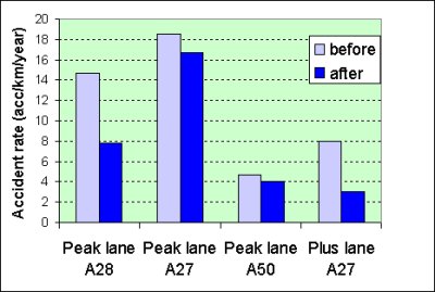
In addition to allowing temporary use of the right shoulder, the Dutch also deploy the use of traveling on a dynamic lane on the median side of the roadway. As figure 36 shows, the left lane—also known as the plus lane, or a narrowed extra lane provided by reconstructing the existing roadway while keeping the hard shoulder—is opened for travel use when traffic volumes reach levels that indicate congestion is growing.
Figure 36: Plus lane in the Netherlands.
The Dutch have seen a reduction in incidents on facilities with a plus lane, as shown in figure 37. Additional safety benefits may include fewer queues and shock waves, lower travel speeds with harmonization, better monitoring, and swifter incident response.(45) As in Germany, temporary shoulder use is allowed only when speed harmonization is in effect. Also, additional facilities are always implemented along with temporary shoulder use to help mitigate any adverse safety consequences the operational strategy may create, including the following:
Figure 37: Incident reductions for Dutch temporary shoulder use.
A new congestion management strategy in pilot testing on the A44, A12, and A50 is dynamic lane marking. Technical performance has proved satisfying on the A44 test track, and human factors testing on the A12 and A50 will be highlighted in 2007. The advantage of using dynamic lane marking is to change the lane configuration on the roadway according to specific traffic demand and lane destination. In theory, a fully dynamic roadway—a so-called flex road concept—could be realized (see figure 38). However, such a high-tech concept of a fully dynamic roadway will not be achieved for a number of years. Meanwhile, the Dutch have planned pilots with uncomplicated traffic solutions of dynamic lane configurations such as off-ramps in sections with hard shoulder running (see figure 38). The lane markings on figure 38 are digitally superimposed for illustrative purposes.
Figure 38: Dynamic lane marking in the Netherlands.
Truck restrictions were first implemented in the Netherlands in 1997 on a 185-km, two-lane motorway during the morning and evening peak travel periods.(50) The restriction prohibits heavy vehicles from passing on the left on these facilities. Since that time, the measure has been extended three times by adding motorways and increasing the duration of the restriction. Currently, the restrictions are on 1,100 km of two-lane motorways. Restricted times are 6 to 10 a.m. and 3 to 7 p.m. on 700 km of motorway and 6 a.m. to 7 p.m. on the remaining 400 km.(50) Also, the restriction is in place when temporary shoulder use is in effect on those motorways. To date, the Dutch have experienced positive results with these restrictions. In addition to a slightly higher capacity (3 percent) on motorways with restrictions, there has been an increase in left-lane travel speed and more stable and homogeneous traffic flow.(50)
Testing of dynamic truck restrictions is underway on select motorways in the Netherlands to assess the potential for more effective implementation. As figure 39 shows, sign gantries display a pictograph when the restrictions are in effect. The system responds to changing roadway conditions and operates fewer hours than the typical static restrictions elsewhere. Preliminary evaluation results are favorable for two-lane facilities with positive opinions from both passenger car and truck drivers.
Figure 39: Dynamic truck restriction testing in the Netherlands.
Ramp metering was first implemented in the Netherlands in 1989 to relieve motorway congestion, improve merging behavior, and discourage drivers from exiting the facility for a short distance to avoid congestion on the motorway (locally known as "rat runners").(45) Figure 40 shows a typical installation for a two-lane ramp, which includes two signal heads on an overhead gantry and ground-mounted signal heads on each side of the ramp that face the driver at the stop bar. Each installation provides a bypass lane for emergency vehicles and buses, and the typical length of a slip-ramp with metering is 300 m. Many ramps use photo enforcement cameras to record violations.
Figure 40: Ramp metering in the Netherlands.

To date, 44 ramps have installations with another 16 planned, a testament to the success of this congestion management strategy. Benefits of these meters include an increase in motorway speeds, a major reduction in shock waves on the motorways, a reduction in short trips, fewer incidents, and a capacity increase on the general purpose lanes of up to 5 percent.(45),(43)
Dynamic route information was first used in the Netherlands in 1990. Today, more than 100 gantries displaying these panels are used across the country on major motorways with another 22 planned.(45) Shown in figure 41, these panels (which can be either DMS or rotational prism signs) are intended to provide en route information on queues, major incidents, and appropriate routes.
Figure 41: Dynamic route information panels in the Netherlands.
The systems provide users with a more satisfactory and less stressful trip because they are more informed about roadway conditions.(45) Several assessment studies indicate that under normal conditions, between 8 and 10 percent of motorists adhere to the revised route information and that overall network performance may increase up to 5 percent. While the information panels are an effective congestion management strategy today, the Dutch believe that the long-term usefulness of this strategy may be limited because they anticipate that all critical road and traffic information will eventually be provided to the user in the vehicle.(45) Furthermore, Dutch law does not require the government to provide traveler information directly to users. Instead, information is sold or provided to independent information service providers who repackage that information and disseminate it through various sources.
The only tidal flow (reversible flow) lane in the Netherlands, shown in figure 42, was originally opened as a carpool lane in 1992. This reversible-flow lane operates in the morning peak inbound direction toward Amsterdam and outbound in the evening.(45) The facility operated as a carpool lane only for about 4 months, and is now available to all users. Political pressure, a lack of communication with the public, and underutilization were several reasons behind the operational change.
Figure 42: Tidal flow lane in the Netherlands.
Automated speed enforcement is in the testing phase in the Netherlands. Figure 43 illustrates an installation of the system. The impetus behind automated enforcement is better air quality and air pollution reduction.(45)
Figure 43: Automated speed enforcement testing in the Netherlands.
Operational strategies classified as managed lanes according to the U.S. definition include speed harmonization combined with temporary shoulder use and queue warning, truck restrictions, dynamic lane markings, and the tidal flow facility. These strategies involve the active management of the facility and the combination of eligibility requirements to optimize throughput on the roadway network.
Like other countries across Europe, the United Kingdom faces a number of new transportation and mobility challenges. Traffic growth trends indicated that volumes will increase 29 percent by the year 2010, and with increased volume comes increased congestion on the transportation network.(51) Estimates are that nonrecurrent congestion in the form of incidents (25 percent) and construction (10 percent) account for 35 percent of this congestion. Thus, in 2004 the Department for Transport established a long-term strategy for a modern, efficient, and sustainable transport system supported by a high level of investment. Acknowledging that transportation is vital to the economy and quality of life, the strategy focuses on providing a transportation network for 2030 that can meet the challenges of a growing economy and increasing travel demand while achieving environmental objectives.(52) Three themes support this strategy: (1) a sustained investment in the transportation network over the long term, (2) continued improvements in transportation management to maximize the benefits of public spending, and (3) planning for the future and considering new and innovative approaches to improving transportation. Underlining these themes is the objective to balance the need to travel with the need to improve quality of life.(52)
A primary goal for improving transportation across the United Kingdom is related to safety. The national goal, in place since 2000, is to maintain the network in a safe and serviceable condition.(53) A key activity is a continuous review of measures to improve roadway safety and that of work zone personnel through engineering and design improvements. Specific numbers the Highways Agency is working to meet include a 33 percent reduction in the number of deaths or severe injuries in motor vehicle-related incidents and a 10 percent reduction in minor injuries— both of which will contribute to a 50 percent reduction in child casualties.(53)
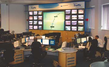
From the perspective of congestion management, the Department for Transport and the Highways Agency have committed to establishing a national focal point in the form of the National Traffic Control Center (NTCC). Construction began in 2001 and operations commenced in 2003 by a private concessionaire under contract with the Highways Agency. The information hub of the Highways Agency, the NTCC has a staff that monitors a network of more 1,730 CCTV cameras and 4,450 traffic sensors 24 hours a day, 365 days a year.(54) As figure 44 shows, staff members review the network and deliver vital information to the news media and other operational partners, including the police and the Highways Agency Traffic Officer Service. They also display real-time messages on the 350 DMS placed at strategic points on the motorway network.
Figure 44: National Traffic Control Center in Birmingham, England.
An inherent value of the NTCC is that it monitors traffic conditions across the entire country. This public-private partnership works hand-in-hand to provide real-time information to the user by building a picture of anticipated roadway conditions. It coordinates planned events across the various regions as well as actions related to unplanned events to ensure that regional decisions on traffic control and traveler information have minimal impact on the local road network. The "Traffic England" Web site, the online disseminator of information from the NTCC, also serves as a central location to access regional traffic information from the regional control centers.
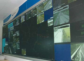
The NTCC coordinates and is interconnected with seven regional control centers across the country. These centers, one of which is shown in figure 45, monitor and maintain the roadway network within their jurisdictions and are the first line of control on congestion management. If minor incidents occur, the regional centers initiate appropriate responses related to incident and congestion management and report information on the incident to the NTCC. For major incidents, actions are coordinated with the NTCC to optimize the remaining capacity and minimize the duration and impact of the incident on the entire motorway network and the adjacent local road system.
Figure 45: West Midlands Traffic Control Center in Birmingham, England.
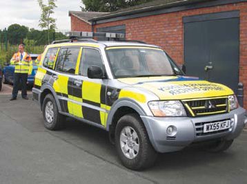
To support the regional traffic control centers in their duties to manage congestion, the Highways Agency also has a program to address incident management that began as a pilot in 2004 with full deployment expected by the end of 2006. The Traffic Officer Service consists of trained personnel who help tackle congestion by patrolling the motorways 24 hours a day, 7 days a week to assist motorists involved in incidents. In particular, they do the following:
As shown in figure 46, traffic officers wear special high-visibility clothing and drive in conspicuous Highways Agency vehicles. A unique aspect of the Traffic Officer program is that the officers have powers under the Traffic Management Act 2004 to stop and direct traffic or temporarily close lanes or roads.(55) Thus, police officers are able to concentrate on investigating the incident, which can help reduce its overall duration. The Highways Agency estimates that 25 percent of all congestion on England's motorways is caused by incidents, and the Traffic Officer Service aims to cut incident-related congestion by focusing on getting traffic moving around incidents as quickly as possible.(55)
Figure 46: Traffic officer and vehicle in Birmingham,England.
Communications and data collection are critical to ensure constant coordination between the NTCC and regional centers. Hence, the Highways Agency manages and maintains a communications network within the motorway right-of-way that is a mixture of fiber and copper cables that transmit voice and data signals from thousands of roadside devices.(54) In its commitment to developing a communications network that optimizes the existing roadway infrastructure, the Highways Agency established the National Roads Telecommunications Services (NRTS) project. This project, constructed between 2003 and 2005 and operated through a public-private partnership, serves as a single national approach to the future of the communications network on England's motorway and trunk network.(54) The project involved upgrading and expanding the existing communications infrastructure to provide reliable service and monitoring of telecommunications from roadside devices to the regional traffic control centers and the NTCC.
Once the control centers receive critical data from the field, they rapidly disseminate relevant information to more than 40 partners to ensure consistency of messages delivered to the motoring public. Some of the methods by which roadway users receive information include the Highway Agency Information Line (HAIL), dynamic message signs, live Internet updates, messages to mobile phones, interactive kiosks at motorist service areas, displays at shopping centers, ports, and airports, and Highways Agency radio. In addition, the motorway online assistant (MOLA) is a real-time network model that uses field data to predict traffic conditions up to an hour in the future. (56) Another unique forecasting tool is provided on the Highways Agency "Traffic England" Web site, where users can select a region and request a traffic prediction for a specific time up to 24 hours in the future.(57) The site also plays an animation for the selected time, providing travelers with expected traffic conditions for travel planning purposes.
Performance monitoring in the United Kingdom provides the foundation to assess how well the Highways Agency meets a primary objective of travel time reliability. The method to be used to meet this objective is to focus on improving the average delay on the slowest 10 percent of journeys on the motorway network.(53) Performance measures calculated from field data include average delay, total delay, and the vehicle miles traveled along a route. Efforts to improve reliability, discussed elsewhere in this section, include incident management strategies, better coordination of the network, an emphasis on customer satisfaction, and an investment in technology to support all activities of the agency.(53)
The following sections summarize specific strategies undertaken by agencies in the United Kingdom to manage congestion on critical roadway networks. Strategies include speed harmonization, temporary shoulder use, truck restrictions, ramp metering, automated speed enforcement, and pricing.
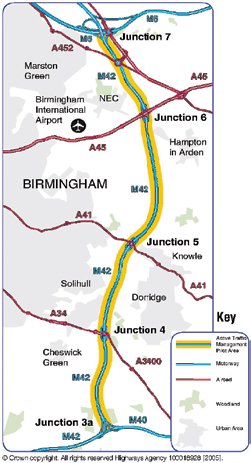
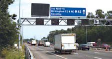
Introduced in 2001 by the Minister of Transport, the Active Traffic Management (ATM) pilot is a new operational strategy intended to provide reliable journeys, reduced recurring and nonrecurring congestion, and enhanced information to drivers.(58) It is a direct response to road users' demands for better service within the realistic limitations of widening and expanding the roadway network. Building on advancements in technology and experience from across the globe, this pilot project will work to make the best use of the existing capacity on a segment of the M42, the limits of which are shown in figure 47. The ATM pilot will also provide additional capacity during periods of congestion or incidents. Construction began in 2003 and the completed system includes installation of the following:
Figure 47: M42 ATM project limits.
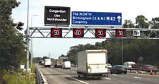
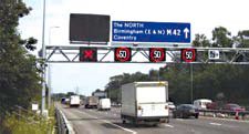
As illustrated in figure 48, the roadway will provide traditional roadway information to travelers seen on other motorways across the region. Under such conditions, all normal motorway rules apply. However, information provided to travelers will change during incidents (see figure 49) or periods of recurring congestion (see figure 50), depending on whether the hard shoulder is open for travel. In both cases, lane control signals indicate reduced speed limits and the availability of the hard shoulder for travel use rather than for emergency refuge only. The M42 system is similar to the successful system installed on the M25 in 1995. Benefits from the M25 installation, also expected from the M42, include enhanced journey reliability, improved driver behavior, and reductions in driver stress, the number and severity of crashes, traffic noise, emissions, and fuel consumption.(60)
Figure 48: M42 ATM under normal motorway conditions.
Figure 49: M42 ATM with hard shoulder running.
Figure 50: M42 ATM without hard shoulder running and incident.
Also, dynamic message signs provide additional information to travelers on ATM operations. Design modifications being planned to aid facility use include a change in the rumble strip between the general purpose lane and the shoulder. In the ATM section, the noise and vibration generated by the rumble strip will be reduced to a humming sound to alert motorists when they cross the line since more frequent access to the hard shoulder will be provided to motorists.(58) Operation of the system will be handled by the regional control center, with operators on hand to monitor the system, initiate the modified operations as necessary, and use a computerized system to calculate appropriate travel speeds during congestion or incidents.(58)
The origins of the ATM system are in the Motorway Incident Detection and Automatic Signaling (MIDAS) system in which speed, flow, and occupancy are detected along an instrumented motorway. Based on field data, MIDAS sets suitable speed limits when traffic flow drops below a set level in an effort to preserve capacity on the facility.(51) The system deactivates when traffic flow returns to normal. Benefits of MIDAS include an 18 percent reduction in incidents, resulting in millions saved each year on incidents and congestion.(56)
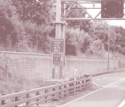
A major component of the ATM system on the M42 is the availability of the shoulder for travel use rather than for emergency refuge only. To ensure safe operation of the temporary shoulder use, emergency refuge areas are spaced at 500-m intervals along the shoulder (see figure 51) and emergency call boxes are provided at each refuge area (see figure 52). Operation of the system is handled by the regional control center, with operators on hand to monitor the system and initiate the modified operations as necessary.(58) Specifically, operators use CCTVs mounted on light sign gantries or separately to check for incidents and stalled vehicles in the shoulder before activating the system.
Figure 51: Shoulder use in England.
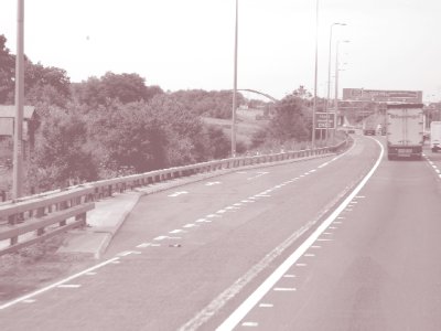
Figure 52: Emergency refuge area and call boxes in England.
Temporary use of the shoulder as a running lane is implemented only under controlled conditions. Dynamically used to relieve congestion and manage incidents, the strategy is deployed with mandatory speed limits, the maximum of which is 80.5 km/h (50 miles per hour).(51) Furthermore, the strategy is provided only between junctions, requiring users to exit at each junction and reenter the motorway beyond.
The first truck restrictions in England have been implemented on a pilot basis on northbound M42 near Warwickshire between 7 a.m. and 7 p.m. The 4.8-km (3-mile) stretch between Junction 10 (Tamworth) and Junction 11 (Appleby Magna) is only two lanes in each direction and heavy vehicles, which make up 17 percent of the traffic, must travel slowly up the steep grade.(61) The ban, in effect for an 18-month trial period, prevents heavy trucks from overtaking each other and restricts them to the inside lane, leaving the outside lane for faster moving vehicles. The intent is to enhance operations and safety and reduce congestion along this part of the roadway. Results of the pilot, including safety impacts and travel time savings, are still unknown.
The first pilot ramp metering project in the United Kingdom was installed on the M6 near Birmingham in 1986. Its purpose was to reduce congestion at the ramp by limiting traffic entering the motorway from the ramp and to enhance traffic flow downstream of the junction.(62) A detailed assessment of operations through data monitoring yielded promising results. On average, vehicle flow increased 5 percent at the implementation location and motorway speeds increased 14 to 18 percent at some locations.(62) Also, no negative impacts were experienced from ramp meter queues spilling into the adjacent intersections and driver compliance was high. As a result of the pilot's success, the system was updated and expanded to five additional locations on the M6, and another 30 are expected to be implemented on the M27 in 2007.(56)
Automated enforcement cameras will be used to enforce the ATM on the M42. Once speed limits are mandatory within the roadway segment, digital cameras will be used to record license plates of violators. The intent is to ensure compliance with the speed harmonization indicators for the safe and effective operation of the scheme in reducing congestion and the impact of incidents.(54) Gantries over the roadway will have static signs indicating the use of automated enforcement, as shown in figure 53.(51)
Figure 53: Automated speed enforcement sign in England.
To date, the success of congestion charging in central London has illustrated that pricing has potential for reducing roadway congestion. As displayed in figure 54, the zone in which travelers are charged is central London, a region that was the most congested with average speeds of 14.5 km/h (9 mi/h) despite 85 percent public transport usage.(63) Since its inception in 2004, the strategy has had positive results. Essentially, congestion is down 30 percent with a decrease in all traffic entering the zone of 18 percent (33 percent for automobiles).(63) The number of trips into the central part of London has not changed; travelers switch modes, divert around the zone, or make other changes to their travel behavior. Emissions in the charging zone have also decreased, including a 12 to 16 percent reduction in nitrogen oxides (NOx), a 12 to 16 percent reduction in particulate matter (PM10), and a 19 percent reduction in carbon dioxide (CO2).(63) The zone will be expanded to encompass a larger area that still sees high congestion levels.
Figure 54: Congestion charging zone in London.
Pricing is also on the horizon as a smarter and more credible long-term option for maintaining the infrastructure in the United Kingdom. It will help ensure that users pay their appropriate share based on roadway use.(64) With vehicle ownership and demand on the infrastructure increasing, the limited resources for operations and maintenance are stretched and new roads are not favorable. Thus, the Department for Transport is assessing the feasibility of implementing pilot road pricing schemes in strategic locations across the country as early as 2010.(64) The intent is to build on commercially available systems that record usage and reduce the need to install equipment gantries all over the network to register usage. Only time will show how this approach emerges to handle both infrastructure funding and congestion management.
The active traffic management project along the M42 represents the best example of managed lanes in the United Kingdom as they relate to the U.S. definition. The combination of speed harmonization and temporary shoulder use works to optimize the use of the existing infrastructure at a fraction of the cost of expanding the facility. Also, the United Kingdom is on the verge of implementing two high-occupancy vehicle (HOV) facilities to manage congestion, indicating the direction of managed lanes in the country.
One HOV project in the United Kingdom is the M606–M62 HOV gate. This junction is a major strategy route between Leeds and Manchester with an ADT of 140,000 and 24 percent truck traffic on a typical day.(65) Since widening of this junction is not a near-term solution, transportation officials determined that a short-term solution to congestion at this bottleneck is to remove the hard shoulder and designate it as an HOV lane, as shown in figure 55. This quick and relatively inexpensive conversion will provide travel time savings to the HOVs in the corridor (approximately 16 percent) without negatively impacting the non-HOV users.(65) The Highways Agency is assessing another 10 locations on the motorway network to determine the feasibility of a similar solution to other critical bottlenecks.
Figure 55: M606-M62 HOV gate design.
Figure 56: M1 HOV lane project.
The Highways Agency is also developing an HOV lane along the M1 northwest of London. As illustrated in figure 56, the HOV lane would operate initially between junctions 7 and 10 with a possibility of extending the lane to junction 13.(66) The HOV lane is a late addition to a widening project on the M1 and will operate in the inside lane as a nonbarrier-separated, continuous-access facility with no buffer. The lane will operate 24 hours a day, 7 days a week, and eligible users will include vehicles with two or more occupants, motorcycles, and possibly buses. Trucks, single-occupant taxis, and vehicles towing a trailer will be prohibited from using the lane.(66) Transportation officials are also assessing how to best actively operate the facility, particularly with the possible deployment of speed harmonization in the corridor.
| << Previous | Contents | Next >> |