U.S. Department of Transportation
Federal Highway Administration
1200 New Jersey Avenue, SE
Washington, DC 20590
202-366-4000
The crash investigation unit of the New South Wales Police was formed in 1982 to provide a specialist unit to investigate fatal and serious injury collisions that may result in criminal charges. The metropolitan area has an authorized strength of 32 members split into three teams. The country units comprise another 20 officers. The teams attend crashes under the following conditions:
The responsibility of the teams is to perform a crash investigation that includes the following:
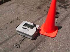
The teams often test new technologies for performing their onsite data collection tasks. Along with the U.S. Marine Corps, the New South Wales Police Crash Investigation Unit is evaluating the use of the DART drag sled to measure the friction of the road surface. This equipment is shown in figure 17. One condition of testing new technologies for data collection is to evaluate the balance between accuracy and speed in an effort to improve both procedures and response time.
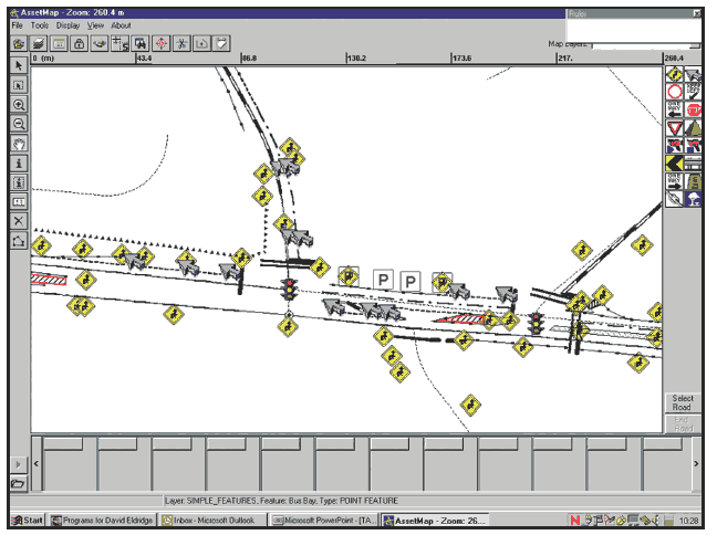
The Traffic Asset Inventory Management System (TAIMS) stores all traffic assets on state and national roads in New South Wales, such as longitudinal line markings, raised pavement markers, transverse and other markings, minor and major signs, safety barriers, guideposts, location of traffic signals, and more. A computer screen illustrated in figure 18 shows the traffic assets on the AssetMap application.
|
|
The transport management center (TMC) in Melbourne covers the motorways, highways, arterial roads, local roads, central business districts, major transport modes, and major event venues. TMC objectives include the following:
TMC is in operation 24 hours a day, 7 days a week. In 2002, the TMC operations room managed more than 20,000 incidents and received 250,000 phone calls to its public and stakeholder lines. In addition to phone call services, TMC relays traveler information via the Internet, radio, variable message signs, and onboard vehicle information systems. Tools used by TMC for traffic management include the following:
TMC uses any combination of these traffic management tools, as well as traveler information, to maintain road network mobility and safety. While not all of the continuous data collected from these tools are now used, it would be possible to do so from saved archives.
New South Wales is divided into six regions, and sample surveys are conducted in two regions per year to count axle pairs, vehicle classification, and traffic volumes. There are 490 permanent traffic count sites, 1,500 sample axle pair and sample classification sites, and 33 weigh-in-motion (WIM) sites. New technologies for traffic data collection are gradually being introduced to do the following:
In addition to the traffic surveys, the New South Wales Department of Transport (via the Australian Bureau of Statistics) has undertaken household travel surveys on an ongoing basis since 1997. Data are collected by door-to-door interviews using a questionnaire format to record trip information. The average response rate is about 65 percent. Information on names and genders is treated as confidential, and no age information is collected. Using these surveys, the DOT compiles statistics on motor vehicle use, including trip patterns, summaries of which are accessible via the Internet. In addition, limited sample size telephone surveys on trip patterns and safety issues are conducted.
The Trauma Minimum Data Set was begun in 2002 after the establishment of the New South Wales Institute of Trauma and Injury Management and is being used in trauma centers throughout the Sydney metropolitan area. The first year of data collection confirmed that road trauma is still the major cause of serious injury. Extensive data are now available for patients who had an injury severity score greater than 15, which is consistent across the trauma services in Sydney. Since this project has just begun, it is not clear yet how these data will be linked or used by those working in road safety.
ARRB Transport Research had conducted hundreds of projects for Austroads that have resulted in new methodologies, strategies, software, and hardware solutions to improve road safety and safety data collection.
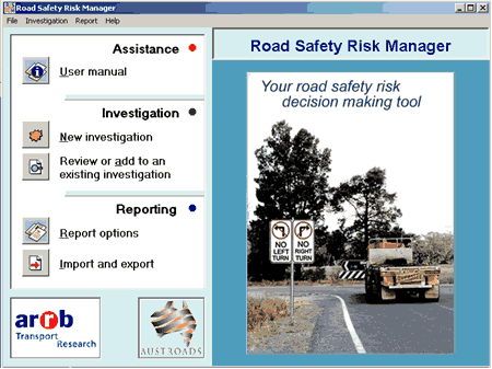
To help members of Austroads manage road-based crash risk factors, ARRB Transport Research developed a computer-based "expert" system called the Road Safety Risk Manager (RSRM). This system, shown in figure 19, is designed to be used as a tool for programming road safety improvements and is based on relationships between road elements and crash risk that have been identified or developed from available literature. Application of RSRM is expected to (1) reduce the risk of road crashes and road trauma, (2) reduce the risk of crashes resulting in fatalities or serious injuries, (3) provide economic benefits to the community as a result of fewer and less severe crashes, and (4) reduce legal action against road authorities that may result from crashes.
Potential uses for RSRM include the following:
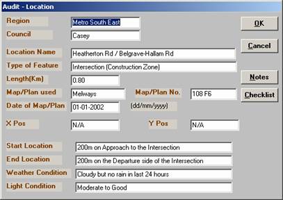
The Road Safety Advisory Audit System provides a mechanism to document the process and results of road safety audits. Figure 20 shows an example of documenting the location for an audit.
XLIMITS is an advisory speed limit expert system into which road environment; functions, hazards, traffic signals, modal activity, crash records, and numerous other factors are entered. The purpose of this software is to establish a credible speed limit for a roadway that can be consistently applied and enforced by the police.
Road authorities need data to assist them in the following tasks:
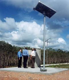
Weigh-in-motion (WIM) technology provides traffic volumes, speeds, axle loads, vehicle types, and headway (the distance between vehicles) to assist in these activities. WIM sites are remotely connected to the office via a landline or a mobile phone network, as shown in figure 21. The advantages of remote connection include the following:
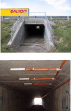
One method used to collect measurements, such as dynamic axle mass of a moving vehicle or traffic volume and mix, without disrupting the traffic flow is to place sensors under a culvert, as illustrated in figure 22.
For freeway applications, ARRB has developed a WIM system that uses in-road sensors that provide vehicle mass, volume, speed, and classification data. These sensors are installed in slots cut into the road surface of asphalt or concrete. The slots are grouted with epoxy and silica sand to closely match the road surface.
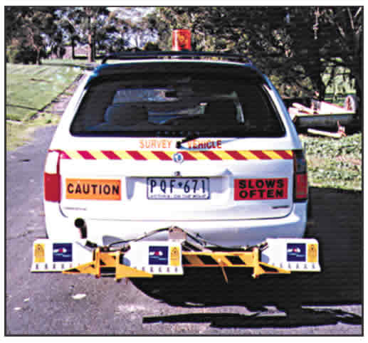
A portable laser profiler system, shown in figure 24, collects road surface condition data while traveling at highway speeds. This profiler comes with an onboard computer, conditioning electronics, odometer system, and software for data acquisition and analysis. This portable profiler can be mounted on a range of vehicles, and measurement is independent of vehicle suspension and tire characteristics. Data can be reported as longitudinal height profile, IRI, Rut Index, and optional pavement surface macro texture.
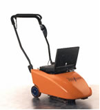
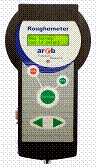
While profilers can be used on sealed roads, a high percentage of roadways in New South Wales are unsealed. For those roads, ARRB developed the Roughometer. Shown in figure 25, it is a convenient measurement device that can provide an objective assessment of ride quality or road roughness for unsealed roads. The Roughometer can be fitted to the vehicle with a sensor attached to the rear axle, and the portable control device can be plugged in when a survey begins.
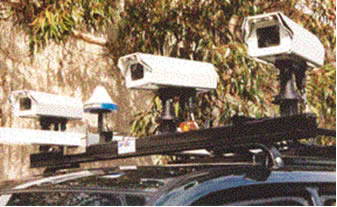
An example of digital video imaging mounted on the top of a vehicle is shown in figure 26. This technology is used to identify and measure pavement distress, measure and classify road surface markings, locate and classify roadside assets, assess and classify roadside conditions, and log kilometer posts for road alignment. This system consists of vehicle-mounted video cameras that capture images that can be displayed in real time. The captured images can be stored on a variety of media for future use. The digital video images can be logged at highway speeds, and a differential GPS option is available to locate the images more accurately.
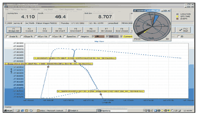
The Gipsi-Trac (Global Inertial Positioning System Integration Tracking Route Alignment and Crossfall) is a vehicle-mounted data acquisition system that uses GPS and sensors to record continuous three-dimensional highway maps and road geometry information. The system can provide latitude, longitude, and height at 10-meter intervals.
A laptop computer is used to operate this system and to process and store the survey data. This system is easily installed in most standard vehicles and operates in all locations. An important feature is the ability to fully process and verify the survey data while the survey vehicle is still onsite. During operation of the Gipsi-Trac, the vehicle data acquisition screen, shown in figure 27, provides field operators with immediate survey-quality feedback.
Following are some of the road questions that can be answered with Gipsi-Trac survey data:
The Monash University Accident Research Center (MUARC) is Australia's largest multidisciplinary research center specializing in the study of injury and injury prevention. Its research and evaluation studies often depend on accurate, comprehensive, and timely databases. For this reason, MUARC has become involved in creating, maintaining, enhancing, and analyzing data from multiple sources, including (1) coroners, (2) motor vehicle crash reports, (3) workers' compensation systems, (4) hospital inpatient and emergency department surveillance systems, (5) cost databases, and (6) population data.
While the desired level of detail is not always available, MUARC continually works with data initiators to improve the specificity and quality of data. Linkage of the various databases is usually a necessity for the research conducted by MUARC staff.
In addition to using existing data sources, MUARC collects data for specific studies, such as multidisciplinary reconstructions of crashes. Among numerous other studies, MUARC established the cost-benefit of accident blackspot investments. By determining the best kinds of treatments, MUARC identified more effective programs for implementation.
| << Previous | Contents | Next >> |