U.S. Department of Transportation
Federal Highway Administration
1200 New Jersey Avenue, SE
Washington, DC 20590
202-366-4000
As anticipated, the scanning team did not find technologies that were significantly different from those used in some States in the numerous efforts already underway to improve traffic safety information systems in the United States. Nevertheless, each country visited provided information with the potential to advance the effectiveness and utility of traffic safety information systems in the United States. In many cases, improvements addressed issues such as coordination, communication, and marketing efforts, rather than technology improvements.
This chapter summarizes the topics discussed and technologies observed in each country visited. Because of the overall context of the scan, it was often necessary to discuss traffic safety programs in general, as well as the systems that support those programs. The findings that the team members believe were most significant are summarized in Chapter Three, and implementation strategies are discussed in Chapter Four.
The scanning team met with numerous representatives of the following groups in the Netherlands:
Team members discussed a significant number of safety systems issues with the experts in the Netherlands. The items summarized in this report focus on the issues that dealt primarily with traffic safety information systems.
The Netherlands is about twice the size of New Jersey and in 2000 had some 16 million inhabitants. Its size is 42,000 square kilometers, of which 8,000 km2 are waterways. By comparison, the United States has 280 million inhabitants, and its size is about 9.4 million km2. The State of New York, for example, is larger than the Netherlands with some 128,000 km2. The Netherlands has 2,300 km of motorways, compared to 74,000 km of interstate highways in the United States.
Rijkswaterstaat is composed of nine regional directorates, 12 provinces, 489 municipalities, seven greater city areas, and 48 water board districts. In addition to the responsibilities of Rijkswaterstaat for roadways, local provinces, municipalities, and water boards are responsible for their own roadways. The only police force in the country, the National Police Agency, consists of 25 police regions and 125 police districts.
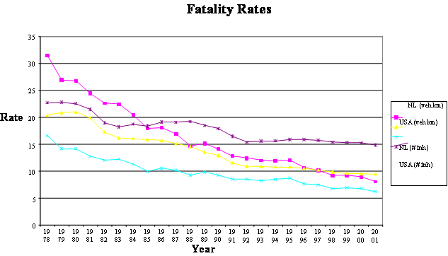
In 2002, the Netherlands reported 1,082 fatalities and more than 18,000 serious injuries as a result of motor vehicle crashes. In the Netherlands, motor vehicles include traditional automobiles as well as bicycles, mopeds, electrical cars, and other means of motorized transport. Figure 6 compares the fatality rates per kilometer and per population between the Netherlands and the United States.
In 1985, the Netherlands set road safety targets to reduce crash injuries by 25 percent by the year 2000, and to reduce serious crash injuries by 50 percent and crash fatalities by 40 percent by the year 2010. To meet these targets, safety policies were focused on vulnerable road users (VRUs), and programs were established for the elderly, cyclists and mopeds, driving under the influence, safety devices, speeding, and heavy goods vehicles. While these programs were considered successful, the targets were not being met. Based on crash data and evaluation studies of the implemented programs, new targets were established for 2010 to have fewer than 950 fatalities and fewer than 17,500 persons hospitalized because of a crash.
AVV Transport Research Center, working for the Ministry of Transport and other governmental bodies active in the field of traffic and transport, considers road safety as a product with a target market. In this context, the center spells out six product groups: (1) freight transport, (2) nautical information, (3) road networks, (4) people transport, (5) traffic information, and (6) road safety.
Within the road safety product group, for example, AVV works on six "clusters," or road safety programs. Clusters related to traffic safety information systems include constructing and maintaining basic data files, producing incidental and repetitive products based on these data files, and measuring the effects of road safety campaigns.
Construction and maintenance of basic data files. To estimate the real dimension of the road safety problem, AVV uses recorded data about fatal crashes, hospitalized crash participants, those injured who receive first-aid treatment, those slightly injured, and material damage-only crashes. These data do not exist in a single, consolidated crash database, but instead come from numerous databases and sources. For example, AVV has determined that VRUs are often underreported in research on mobility and safety. The traditional VRUs are those walking, bicycling, and riding mopeds or motorcycles. Crashes involving cyclists are the most underreported. To obtain this information, it has been necessary to look for supplemental data sources. This project to collect data for VRUs is discussed in more detail later in this section. Table 3 shows the difference between recorded crash data reported at the time of the accident, and estimated crash data for the same period. Road safety planning, implementation, and evaluation are performed using the estimated crash data, which are believed to represent the true dimension of the safety condition of the road. At the national level, funding allocation is based on crash data estimates.
In a presentation, Peter Mak of AVV said that flexible and accessible databases that are stable, consistent, unified, harmonized, and up-to-date in time and content are the bricks of any system. To get this basic information, the important issues are the following:
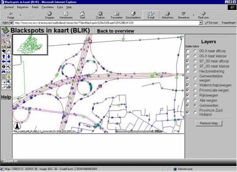
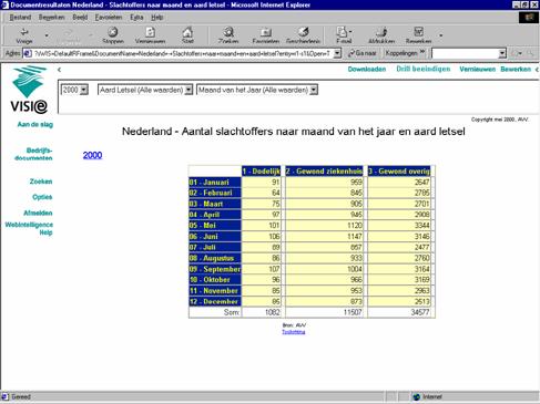
Production of incidental and repetitive products based on data files. Incidental and repetitive products include analysis files, analysis applications, and standard reporting. Examples of routine applications include the mapped blackspots (areas with high crash rates) shown in figure 7 and road accidents on the Internet (Ministerie van Verkeeren Waterstaat) shown in figure 8. Examples of standard reports include reported accidents and casualties, risk ratings on national roads, and an annual input quality report.
Measurement of the effects of road safety campaigns. Road safety campaigns are initiated to influence driver behavior, and the effectiveness of these campaigns is measured. Examples of road safety campaigns include those on drinking and driving, seatbelt use, bicycle lighting use, social costs of unsafe roads, periodic regional road safety surveys, and road safety bulletins. The biggest user of these products is the Ministry of Transport, followed by the National Road Administration, provinces and regional road safety organizations, municipalities, district water boards, research institutes, police, consultants, educational institutions, interest groups, students and citizens, and others.
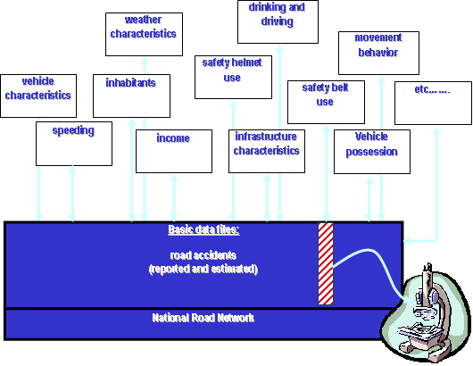
Safety data information is marketed as a commodity, with more perceived value than just the available information. To market their products to customers, organizations focused on road safety stress communication, marketing (including market research and segmentation), promotional activities (including trade exhibitions and promotional objects), and feedback (including periodic meetings with customer groups and a service desk to answer questions). To further improve road safety products, a model shown in figure 9 illustrates efforts underway to introduce new sources of data. Introducing new data sources requires securing the quality and durability of basic data files, continuing the search for relevant data types, achieving the necessary knowledge to effectively use the new data sources, and keeping informed on traffic safety developments.
The Institute for Road Safety Research (SWOV) is a research foundation with a mission to contribute to road safety through scientific knowledge. It is an independent research institute with a user orientation that provides the following:
In the course of its numerous research activities, SWOV has identified needs for additional, continuous, or improved data in the following areas:
To support the research activities in the institute, the SWOV planning office is responsible for providing information and support. The safety support activities of this department include the following:
The mission of the Netherlands' Organization for Applied Scientific Research (TNO) is to apply technological knowledge with the aim of strengthening the innovative power of industry and government. One of its core areas of expertise is defense and public safety. Accident analysis within TNO in terms of the Dutch Accident Research Team (DART) includes the following activities:
In terms of in depth studies, TNO has collected data for studies about high traffic density, typical road layouts for bicycle and moped lanes, high number of bicycles, high number of heavy trucks at the Port of Rotterdam, and others.
Examples of data collected by TNO include the following:
Examples of data identified by TNO that have been missing or would have been desirable for these studies include the following:
TNO has been collecting in depth information on crashes involving non-passenger cars since 1999. More than 350 cases and an additional 200 control investigations provide a source of detailed information about particular crash types. In depth accident analysis provides useful insight into the causes and consequences of road crashes and is considered important for monitoring new trends and the effects of certain measures.
The Directorate Zuid-Holland is one of 10 regional authorities responsible for state roads in the provinces. This responsibility includes traffic flow, environment, and safety. Safety problems are assessed using data on crashes, exposure, and road characteristics. South Holland is the largest directorate and includes 18 percent of all state-maintained roadways, with 10.5 million vehicle km over 400 km of state roadways. Rijkswaterstaat is subject to political goals on traffic flow, environment, and road safety. To reach these goals during a period of decreasing budget, the directorate's orientation is changing from only maintaining the infrastructure to taking care of traffic flows as well by such methods as speed and incident management. Increased underreporting of crashes is regarded as a substantial problem because it makes it more difficult to focus attention on road safety or to identify priority locations for improvements.
AVV believed that VRUs are often underreported in research on mobility and safety, including traditional VRUs such as those walking, cycling, and riding mopeds or motorcycles. The project on VRUs requires gathering data on the size of the problem, mobility, crashes and risks, measuring analysis, and other factors. To obtain this information, it has been necessary to look for supplemental data sources. Examples of new data sources include pedestrian diary projects, data from hospitals and family doctors, and additional questions on the behavior and opinion survey (known as PROV) sent out every 2 years to households throughout the Netherlands. Sample PROV questions include the following:
AVV routinely experiences a 70 percent return rate on the survey because of incentives provided to responders. AVV uses the data to supplement its safety research activities and compares it to data from previous surveys. An English translation of the most recently used PROV survey is in Appendix D.
AVV routinely maintains basic databases on the following and other data:
Although the data are used primarily by the Ministry of Transport, they are also used by policymakers, engineers and designers, other road authority jurisdictions, private consulting firms and shippers, police, environmental researchers, and many others.
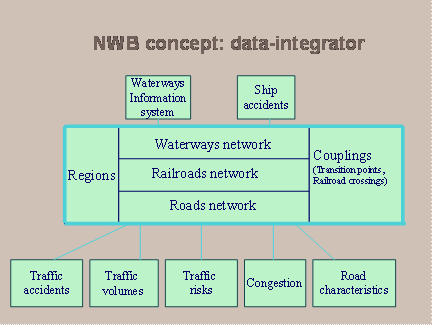
The National Road Network, shown in figure 11, is the information integrator for all of the data. The network began with street and cross-street coding to locate crashes, and was used this way for many years. It was reorganized in 1996 to bring together all of the networks in a GIS database.
This GIS network database includes 145,000 km of roadways and has been available since 1998 for all customers. Each month, a new file of ZIP Codes indicates where new roads have been constructed, and map agencies are contacted to follow up on these system updates. In what is called a "data-for-data partnership," agreements are made between AVV and regional or community jurisdictions to provide updates to their portion of the roadway network in exchange for being able to access the information in the network. This way, localities provide information such as locations, drawings of new streets, and road attributes in exchange for access to all other data linked to the network.
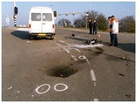
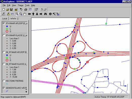
In the accident reporting process used in the Netherlands, AVV staff is responsible for the quality control of location coding. Staff members use the capabilities of the National Road Network GIS to drill down to the appropriate location to verify that it matches the law enforcement officer's description of the location in the accident report form. An example of the level of detail provided by the road network GIS is illustrated in figure 12.
To address the problem of underreporting of different types of crashes, a new proposition for a road accident reporting system will incorporate the following benefits:
As part of this effort to simplify the system, the Netherlands is evaluating the 80 data elements now collected in the field to determine if it is possible to reduce the number to about 40 elements. Officials expect that these police-collected data will be enhanced by linkage to other data sources, as well as by additional sampling techniques.
In addition to researching new methods for collecting and managing traffic safety data, the European Union is attempting to stimulate cooperation among the various police agencies, both within their own countries and on the EU level. As a response, TISPOL, the European Traffic Police Network, a police network similar to the International Association of Chiefs of Police in the United States, was created. TISPOL serves as a network for traffic police forces to improve conditions for cooperation by developing a common EU police strategy on road safety tasks and to provide a higher police profile on the EU level.
Germany is slightly smaller than Montana and in 2000 had some 82.8 million inhabitants (roughly one-third of the population of the entire United States). In Germany, the scanning team met with representatives of the following groups:
Team members discussed a significant number of safety systems issues with the German experts. A translator was used during these discussions to be certain that the ideas and issues were clearly communicated.
Germany is 356,970 km2 or about the size of Montana. Its population of 82.8 million inhabitants, however, is roughly the equivalent of the populations of California, Texas, New York, and Virginia combined. Much of the traffic safety activity in Germany occurs through legislatively mandated local accident commissions composed of police officers and representatives of the road construction and traffic authorities. Since 1971, these local accident commissions have been required to meet and investigate high-risk safety locations (identified by crash records) and determine solutions to the safety concerns at these locations. These local accident commissions have formalized and made commonplace the process of multidisciplinary local safety analysis in Germany.
The Federal Highway Research Institute (BASt) was founded in Germany after the highest number of traffic fatalities (20,000) was experienced. BASt uses both national and international data for developing accident statistics and analysis. The International Road Traffic and Accident Database (IRTAD) is supported at BASt and consists of high-level aggregate data from 30 countries and four continents.
On a national basis, BAST receives all crash data from the 16 German states within 6 months after the end of the year. These data are collected using a national form, with some states adding supplements for other information they wish to collect. The states maintain their own data files for their work, and these data are available on their accident databases within 30 days of the crash. No personal data, except for birth year, are provided to BASt. While underreporting of crashes is a concern, only an estimated 5 percent of crashes involving fatalities or injuries are missing from the databases, and these are believed to be mostly crashes involving pedestrians or bicyclists.
In addition to crash data, BASt has available or maintains information about population, vehicles, roadway kilometers, distances traveled by cars, seatbelt and child restraint use, and other types of data.
All police officers receive consistent and comprehensive traffic safety training through the National Police Leadership Academy. This training includes accident analysis, site inspection, immediate and long-term safety measures, evaluation techniques, and more. Germany has two federal police forces, as well as local police agencies, many of which have different laws and use different crash forms and databases.
Only 12 percent of the 82 million inhabitants, or 6.8 million, are considered traffic participants in Germany. This number includes cyclists and pedestrians as well as drivers. Of the 4.3 million new violations entered onto the driver license database, about 60 percent are for people with no license. From the German perspective, the point is to protect the general public from incompetent drivers. As problems become bigger, permits to drive are withdrawn, and the local authorities are notified. Entries, or violations, are deleted from the file after the appropriate suspension or other penalty has been completed.
Because of privacy laws, no connection or linkage is allowed to driver records, but numerous reports are produced to analyze groups by gender, age, and number of offenses, along with the number of crashes obtained from the accident registry.
The German In depth Accident Study (GIDAS) uses two teams to collect more detailed data on crashes, much like the National Automotive Sampling System (NASS) teams in the United States. While these teams work independently from the police, they record more detailed accident characteristics for special research use. The bias caused by the sampling is corrected by a weighting factor. These data are available for approved use in crash research.
In 1968, a data dictionary was developed as a guidebook for the states to develop their own systems, but instead states developed several individual systems independently. The catalog of variables was redesigned in 1986, and 10 years later the project was canceled when it was decided that it would not be possible on a national basis. Each state now designs its own database, and BASt has access to the information. These local roadway databases include core data such as number of lanes, administrative data, cross section, construction material and depths, and other roadway information.
While the Minister of Transport is responsible for roadways, the responsibility for maintaining and updating data has been delegated to the states. In 1987, the Minister of Transport commissioned a van to get data in the field on roadway characteristics. These data were offered to the states but were refused because the states had their own tools and methodologies. A national GIS database and linear referencing system has been developed, but it is expected to be costly to match the 16 state databases to this new national GIS. OKSTRA is a new data model to define the ability to exchange data with both federal and state participation.
BISStra is the federal highway information system being developed to incorporate data from the bridge management system, pavement management system, cartographic data, crash analysis in terms of prediction, trans-European road network, and other roadway-oriented data. This system contains all roadways except community roads, which are available in the state roadway databases.
In 2001, Germany had 1,106 permanent traffic counters that automatically reported hourly traffic counts for every travel lane. In addition, manual counts are conducted every 5 years for all federal road sections with a differentiation of up to six types of motor vehicles. The states get these traffic data and organize the counts, and then provide traffic information to BASt for analysis.
In 1990, 1993, and 2002, a mileage survey was conducted with motor vehicle owners. The sample size for this survey was about 120,000. The purpose of the survey was to obtain data for miles traveled, vehicle characteristics, regions visited, and purpose of trip, travel time, and driver characteristics such as gender, age, and profession.
EUSka is a crash data collection tool developed by the German Institute of Traffic Engineering, an organization similar to the Insurance Institute for Highway Safety in the United States. This Windows®-based software product allows for simplified collection of crash data for the police officer. Specific editing ensures that all data have been entered before the record can be made official. Included in the system are variables specifically required for the national database. All of the police agencies in four states now use this software. The software, support, and training are available to all police agencies throughout the country from this private institute at no charge.
Conventional street maps with different-colored pins indicating crashes, as well as time-consuming paper work and filing of accident reports, are no longer required. The user can select a crash on the digital map and immediately receive the complete accident report. Crash frequencies can be analyzed by economic damage, as well as by similarities between various crashes.
| << Previous | Contents | Next >> |