U.S. Department of Transportation
Federal Highway Administration
1200 New Jersey Avenue, SE
Washington, DC 20590
202-366-4000
Barcelona has a population of 1.5 million in an area of 100 sq km. The metropolitan area has a population of 4.2 million in a 3,200-sq-km area. Six million trips are made daily in the metropolitan area, 25 percent by private car. Four million trips are made daily within the city. The modal split is 36 percent public transit, 38 percent private car, and 26 percent pedestrians and bicycles.
The technical part of the visit to Barcelona included:
The Catalan Traffic Service is responsible for regional and interregional traffic management and operates the Traffic Information Center (CIVICAT).
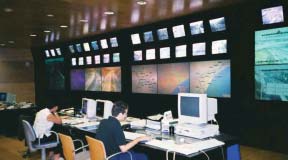 Figure 7. Traffic information center (CIVICAT) in Barcelona.
The CIVICAT has allocated some tasks in the center to public employees, but the operations and management of the service are mainly outsourced to private contractors. Their roles are to operate and manage traffic control, monitor conditions, and disseminate motorist information via DMS.
The system includes 127 CCTVs. The technologies include both digital and analog video. The CIVICAT has agreements with the municipal systems and their motorways, which provides access to 250 additional CCTVs. The images are also provided to TV stations, and are available on the Internet at www.gencat.es/transit.
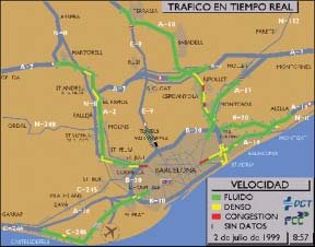 Figure 8. Level of service map.
Detection occurs at 300 stations and includes technologies such as inductive loops and vision processing. Data include speed, flow, occupancy, and vehicle classification, and are collected and sent every minute to the center.
Information dissemination includes a level of service (LOS) map. The LOS map is based on historic, predictive, and real-time data to create the final product. Three colors (red, yellow, and green) are used to display the LOS. The map is displayed on the Internet and for display on DAB devices (on-board navigation).
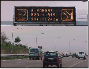 Figure 9. Dynamic message sign showing alternate travel times.
Motorist information is disseminated through 67 DSMs. They are used for advice, warnings, rerouting, travel times, and also for itinerary recommendations, for example, by indicating this message: 15 min to City X on route A or 25 min to City X on Route B. CIVICAT is working with the municipalities to give combined urban and interurban trip times. This functionality should be available in about 1 month and would be the first available in Spain.
For congestion, two types of messages are "incident at" and "congestion until".
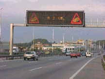
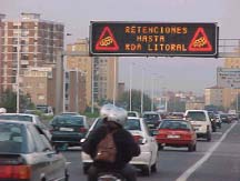
Figure 10. "Incident at" and "congestion
until" messages.
No customer satisfaction surveys are conducted, but not many complaints are received. A survey has found that up to 20 percent of drivers change their normal route when travel time is two or more times greater than their normal travel time. This level was established by comparing loop data to benchmarked data.
The system includes 135 SOS posts for emergency roadside assistance. The increase in cell phones has led to a decrease in SOS use. The telecommunication system includes data flows on a 30-km fiber network around the city, as well as the use of phone lines.
The CIVICAT center includes the Traffic Information Center (CIT) which is a public entity. The CIT produces traffic programs for TV and radio stations as part of public service. Traffic images are broadcast on Catalonia regional TV. Three programs are produced: two weekday programs and one on Sunday evening.
All traveler information is given free to any outlet, but the CIT is considering charging for information to generate revenue sometime in the future. Internet information is provided at: www.gencat.es/transit. Information is delivered via a WAP service offered by cell phone companies. CIVICAT actually puts the information in the WAP format for the private partners to disseminate.
The telephone system uses human operators to provide regional information. The system is part of a national system that offers more than just traffic information. Phone calls are currently at the local rate, and 200,000 calls are received per year. In the past when phone calls were 50 cents (US) per call, they received 50,000 calls per year. The service is outsourced (operator procured by request for proposal), and the costs are now 0.54 Euro per call to the user. Of that total, 0.36 Euro goes to the telephone company and 0.18 Euro goes to the system administrator. The amount is not enough to cover operating costs, however, and requires subsidization. The average call length is less than 3 minutes. The total cost per call for the service is 1.08 Euros to provide the content and to deliver it. The subsidy from CIVICAT is 0.90 Euro per call--0.18 is paid by the user as indicated above; 1.08 is paid to the contracted service operator (per call), and 0.36 goes toward the telecom cost per each call.
The city controls about 1,000 traffic signals in the municipal area. Barcelona has three TMCs. Two centers belong to the city. One is used for traffic signals and lane control for the operation of reversible lanes. The police operate the system and decide what strategy to apply in any given situation. The second TMC was developed for the Olympic Games and controls part of the expressway system. The third center is the CIVICAT center.
The Barcelona City TMC has the following functions:
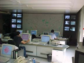 Figure 11. Barcelona City traffic management center.
The interurban TMC operates 24 hours a day, 7 days a week. The operators are a combination of civil servants and contractors and consist of operators, public information officers, journalists, and system technicians. The maintenance for the 250 CCTVs and 300 loop installations has been subcontracted.
The system transmits every-minute speed and flow data and uses the data to populate the system map. It does not report travel times when there are no active incidents. The website has 1,500,000 hits per month and 10 billion pesetas are invested in regional intelligent transportation system (ITS) technology. Most large cities in Spain have contracted out their TMC maintenance and operations.
The municipality's system is called the Urban Mobility Management System. It uses single inductive loop detectors to measure occupancy, but not speed, at 193 sites that have 548 loops at 302 detector stations. Single infrared beams are also used to measure occupancy and volume, but not speed. The municipality is working toward a double infrared beam system for the ring road. Infrared is considered better than loops because it is nonintrusive. Detection by image processing systems was found to be too expensive. It also requires too much bandwidth for communications, or one should have an image processor at each device. There are 1,398 traffic signals in the city that are controlled by 44 zone masters.
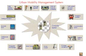 Figure 12. Urban Mobility Management System, Madrid.
The TMC controlling the signal system has three main functions:
Traffic information is provided on the Internet. Traffic cameras on local streets are provided for 19 cameras. Fixed cameras and pan-tilt-zoom cameras are capturing images for the Internet web page where images are updated every 5 minutes (automatically). The ring road has eight cameras, and the images are updated every 15 minutes. Images are only posted after an operator has reviewed and approved them for the Internet. Color speed maps of main streets in Barcelona are provided, and the map also shows Metro stop locations. The map gives current conditions and the expected conditions in the next 15 minutes. The predictions are based on historical information from the last 10 like days (i.e., last 10 Tuesdays). The estimated error is 15 percent and the system works well with normal flow. As expected, the methodology does not work as well during a major incident. It does give travel time and the deviation from normal travel time. The travel time data are verified using a floating car on a daily basis. The city vehicle checks travel times (one street/day), and calibration has yielded a 20 percent error. Travel times that exceed the speed limit are not provided. The web page provides LOS and any total closures. The LOS is based on data from loops and infrared detectors. The loops are primarily for traffic control and are installed downstream 60 m from the intersection. LOS rating is based on predefined thresholds calculated at each of 161 intersections. The thresholds must be changed every time signal timing is changed.
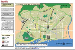 Figure 13. Current traffic status displayed on the web.
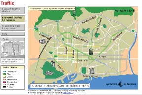 Figure 14. Expected traffic time: 15 minutes.
The tunnel lane controls can be managed from the TMC. The controls can be configured for all traffic to use one tube of the tunnel while maintenance is performed in the other tube.
Changeable warning signs are used for left-turn prohibition at intersections and at multipurpose lanes for parking and loading. General travel is allowed depending on the time of day.
Automated parking information signs are used in two areas of the city. The system provides information for 15 parking garages.
In the city, radio traffic reporting information is made available from the TMC. Information collection includes incident information received by telephone by the police. The police then make reports or provide the data to the media. The radio stations call police at the TMC for information. On weekdays about 100 calls are received. On weekends about 30 calls per day are received. The police also receive calls from other sources at a level of about 40 per weekday and 15 per day during the weekend.
 Figure 15. Extinguishable signs.
CCTV images are made available on TV. Regional TV and Barcelona TV broadcast the CCTV images. The TMC can turn off the broadcast images if they are considered inappropriate for broadcast.
Variable message signs (VMS) are used on the freeway and in urban areas. Twenty-three signs are installed on the ring road, and there are 21 smaller signs in urban areas.
The Internet site for traveler information is available at www.bcn.es/infotransit and forms part of the City of Barcelona web portal. The city public information office oversees the portal development. Data are provided by each responsible city agency (i.e., the department of transportation [DOT] is responsible for traffic information). The website usage per week is 9,932 user sessions or 37,388 pages visited. The average session duration is 8.37 minutes. No marketing or advertising is done for the site. Use of the site is growing. Users are mostly young people, Thursday is the highest use day, and 8:00 PM is the highest use time.
The portal's transportation information includes public transport, traffic, parking, walking, and biking. Currently, the data are independently provided. There are plans to integrate the data. The information is presented as follows:
The public transit authority of Barcelona is called the Metropolitan Transport Authority (ATM), and was founded in 1997. ATM is responsible for city, regional, and national transit in Barcelona.
The transit system consists of:
The ATM is responsible for approximately 750 million trips per year. The patronage is increasing, but not as fast as private car use. The ATM operates park-and-ride lots at the edge of Barcelona. For approximately 800 pesetas the user can park and ride on any transit all day, but only 40 to 50 vehicles use the park-and-ride lot each day. The usage may be low because lots are located too close to the city.
Traveler information data is collected through public transit operators (rail, buses, and Metro) who communicate service information (service disruptions or "normality") every 5 minutes to the Information Center (TRANSMET). The Information Center (created in 1998) transmits information via radio broadcast or to other media by telephone. Real news items are service disruptions or major delays. About 95 percent of the time there are no major news items. Traveler information is requested by telephone by the media. Each station can call in every 2 hours. The information goes on TV teletext, which is currently more ubiquitous than the Internet. ATM does not operate a telephone service. Some companies have real-time information in shelters. In less than 1 year, the interurban busses will have buses with global positioning system (GPS) providing real-time travel information. The ATM does not publish schedules; public and private operators publish their own schedules. The service frequency is 12 buses per hour in urban areas and 4 per hour in other areas. On the Metro, there are 3½-minute headways in the peak hours (15 trains per hour) and 7½-minute headways in the off-peak hours.
| << Previous | Contents | Next >> |