U.S. Department of Transportation
Federal Highway Administration
1200 New Jersey Avenue, SE
Washington, DC 20590
202-366-4000
Safety and mitigation of congestion are two of the most important strategic goals of the U.S. highway community. Long-life concrete pavements require less frequent repair, rehabilitation, and reconstruction, and therefore contribute to improving highway safety and mitigating congestion. Experience with long-life concrete pavements, including examples of concrete pavements that have remained in service for more than 40 years, has been noted in previous scans of European countries. Information about these long-lasting pavements and the design and construction practices that produced them will be valuable to pavement designers in the United States.
In the United States, the typical design life for pavements is about 20 years, although a number of States use longer design lives. Major rehabilitation and reconstruction of pavements are difficult and expensive to accomplish, especially in urban areas. Portland cement concrete (PCC) pavements built in the United States in the future must be designed and constructed for longer service life.
The purpose of this scan was to identify design philosophies, materials requirements, construction procedures, and maintenance strategies (including winter maintenance strategies), used by selected European and other countries to construct and operate portland cement concrete pavements with life expectancies of 40 years or more, that would be applicable in the United States.
The ultimate benefit of the scan will be achieved by implementing technologies that will result in increased service life and reliability and decreased life-cycle costs of concrete pavements built in the United States in the future.
While the U.S. highway community embraces the concept of long-life concrete pavements, it lacks a clear definition of what a long-life concrete pavement should be. The Federal Highway Administration's (FHWA) Concrete Pavement Road Map, formally known as the Long-Term Plan for Concrete Pavement Research and Technology,(1) identifies long-life concrete pavements as one of the 12 major tracks along which concrete pavement research over the next 7 to 10 years should be directed.
The road map team discovered that the concept of long-life pavements was difficult to define. Among the proposed definitions were the following:
Among the features mentioned as necessary to a long-life concrete pavement were the following:
Yet another set of requirements for long-life concrete pavements, sharing some features with those already mentioned and identifying some not mentioned, is outlined in a paper presented at the 8th International Conference on Concrete Pavements.(2)
Given the prevailing lack of clarity and agreement on what a long-life concrete pavement should be, the concrete pavement road map identified the very first objective for this research track as "develop clear and detailed definitions of long-life concrete pavements, including information about warrants, required maintenance, a range of low- to high-traffic roadways, and other information."
The road map team specifically mentioned two topics it believed must be considered to effectively confront the issue of how to build longer-life concrete pavements: use of CRCP and costs. About the use of CRCP, the road map states the following:
"Continuously reinforced concrete pavements (CRCP) should be considered in long-life solutions for heavy-duty pavements, but few States use the technology routinely. It would take considerable effort to reenergize CRCP, but it should be considered because it has a solid performance record in many locations."
About costs, the road map states the following:
"The cost issue should be addressed in any final application of long-life principles. The challenge is not simply to add more 'bells and whistles,' but to add value and performance without increasing the cost significantly. Increasing life and holding the cost are inherent if long-life pavements are to have a role in pavement selection."
The challenge is not to build more conservative designs without improving existing design and construction practices, nor even to add value and performance without increasing the cost significantly. Indeed, the challenge is to increase the cost-effectiveness of concrete pavements by improving performance without increasing costs.
The variety of design, construction, and maintenance practices employed in the countries that have successful experience with long-life concrete pavements is expected to lend useful perspective on the ways long concrete pavement service lives can practically and cost-effectively be achieved.
While many countries build concrete pavements, not all have insights to offer the U.S. highway community on how to design and build long-life concrete pavements. It makes sense that the world's richer countries have the means to make investments in strategic infrastructure improvements such as long-life concrete pavements a high priority. Less economically developed countries must put strategic infrastructure improvement behind more pressing concerns, such as poverty, unemployment, violent crime, and civil unrest.
There are a variety of ways to quantify the wealth and economic development of countries.(3) Perhaps the most familiar measure is per capita (per person) gross national product (GNP). The countries with the highest per capita GNP are the United States, Canada, most of the countries in western Europe, Australia, New Zealand, Japan, and a few countries in the Middle East (although these latter ones, i.e., Israel and some of the petroleum-producing Arab states, rank among less developed economies by other measures).
A better measure of a country's relative wealth than per capita GNP is per capita purchasing power because it includes the relative prices of products. For example, Switzerland, Sweden, and Japan have higher per capita GNPs than the United States, but the United States has the world's highest per capita purchasing power because of relatively lower prices for food, housing, fuel, merchandise, and services. The countries with the highest per capita purchasing power are the United States, Canada, most western European countries, Australia, and Japan. By any of a variety of other specific and widely used economic measures, more or less the same group of countries is consistently identifiable as the world's richest and most highly developed.
In general, the most economically robust and densely populated countries have the greatest need for strategic infrastructure investments such as long-life concrete pavements. Important exceptions exist, however. For example, parts of southeastern Europe (e.g., Romania, Bulgaria, Turkey) and parts of the Indian subcontinent (India, Pakistan, and Bangladesh) are densely populated and have dense road networks, yet are economically far behind the most highly developed countries. India, for example, has an extensive road network, but the roads are overcrowded (traffic on the network has increased thirtyfold since independence in 1948), and 80 percent of villages lack all-weather roads. Other countries, most notably Canada and Australia, are sparsely populated overall, with most of the population concentrated in one or more small regions of the country. These are countries where strategic infrastructure investments such as long-life concrete pavements make sense only for those densely populated zones.
The United States is rather unusual in that it is almost completely blanketed by a dense roadway network, while at the same time it is relatively sparsely and unevenly populated.
Figures 1 and 2 illustrate where the U.S. population is concentrated. These figures provide insight into the regions of the United States for which long-life concrete pavements offer the greatest potential benefit in reducing passenger traffic congestion.
Figure 1: United States population density map based on 2000 census data (1 square mi = 2.59 square km).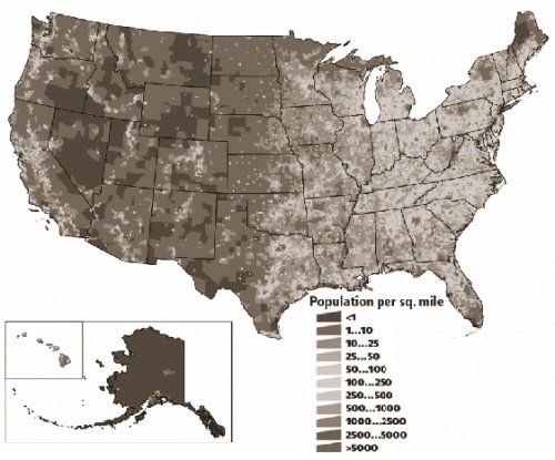
Figure 2: Primary and secondary metropolitan areas of the United States.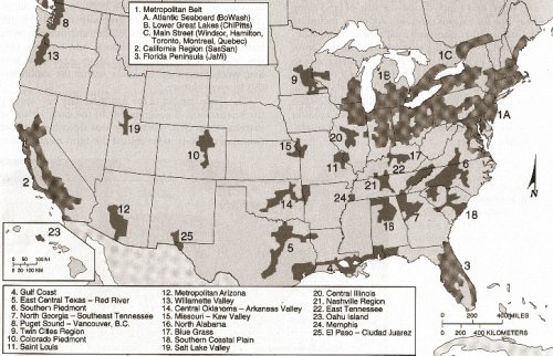
Another important place for long-life concrete pavements in the United States is on the most heavily truck-trafficked Interstate and U.S. routes, including but not limited to the east-west routes I-10, I-20, I-40, I-70, I-80, and I-90, the north-south routes I-5, I-15, I-25, I-35, I-55, I-65, and I-95, and the routes near the major ports (Miami, FL; New Orleans, LA; Houston, TX; Los Angeles, CA; Chicago, IL; and New York/New Jersey) where goods move in and out of the country.
Another factor to consider in assessing where long-life concrete pavements would be of greatest benefit in the United States is the effect that major airports have in spurring business and residential growth. Where there is a very busy airport—even in what once seemed the middle of nowhere—eventually there will be a buildup of commercial activity and housing construction. According to an article about this "aerotropolis" phenomenon in the The Economist, "when Washington Dulles National Airport opened in 1962 in rural Virginia, it was considered a white elephant, but it has spawned a high-tech corridor and now sits in the fastest-growing county in the United States. Denver's ten-year-old international airport, about 40 miles (64 kilometers) out of town, is expected to be the center of a community of 500,000 people by 2025—almost as many people as live in Denver itself."(4) The Economist article further points out that development near an airport is constrained by height restrictions on buildings, which forces growth outward rather than upward.
An additional factor to consider is the unusually rapid growth occurring in other specific regions of the country. Two examples often cited are Phoenix, AZ; and Las Vegas, NV; the fastest and fourth-fastest growing metropolitan areas in the United States. While California and Florida remain popular and populous, people are also moving to Arizona and Nevada in droves, attracted by lower housing prices. In 2005 alone, according to The Economist, 120,000 Californians were expected to move to Arizona, a group equivalent to about 2.5 percent of Arizona's existing population. In Las Vegas, driver's license records suggest that as many as 35 percent of newcomers are from California.(4)
In general, while the most densely populated areas of the United States remain the eastern seaboard and the Great Lakes region, shifts in the population are predominantly toward the southwest, west, and south. According to a recent report on urban sprawl, the top 20 fastest growing counties in the United States are in Arizona, California, Nevada, Texas, Florida, and Washington.(5)
How these and other metropolitan regions in the United States grow in coming years will be influenced by whether sprawl is controlled or uncontrolled, but in either case there is little doubt that these fast-growing regions will continue to experience rapidly increasing levels of traffic congestion. There is also no doubt that traffic congestion levels will be high even in more stably growing major metropolitan regions.
Austria, Belgium, Canada, Germany, the Netherlands, and the United Kingdom were selected for inclusion in this international scan. They were chosen from among the countries that have the means to invest in strategic infrastructure improvements such as long-life concrete pavements, and that have population densities and passenger car and truck levels warranting consideration of long pavement service lives.
Canada—The scan team met in Toronto with representatives of the Ontario and Québec ministries of transport (MTO and MTQ), the Cement Association of Canada (CAC), and the consortium operating the 407 ETR, the world's first all-electronic, open-access toll highway.
Germany—The scan team visited the office of the German Cement Works Association (Verein Deutscher Zementwerke, VDZ) in Düsseldorf and met with personnel from the concrete technology department of the German cement industry's research institute. The team next visited the offices of the German Federal Research Institute (Bundesanstalt für Straßenwesen, BASt) in Bergisch-Gladbach, and then traveled to Munich, visiting concrete pavement sites along the way on the A-5 Autobahn. The team's final meetings in Germany were with faculty and researchers at the Technical University of Munich.
Austria—The scan team toured several concrete pavement sites between Vienna and Salzburg, accompanied by the head of the research institute of the Austrian Cement Industry Association (Vereinigung der Österreichischen Zementindustrie, VÖZ). The team also visited the offices of VÖZ for a meeting with representatives of the Austrian cement industry association and its research institute, as well as representatives of the Austrian Ministry of Transport, the University of Vienna, the Austrian Ministry of Finance, and Austrian concrete pavement consultants and builders. Some team members also visited a concrete paving job site in Austria to see its concrete plant and paving equipment.
While in Austria, the team attended a presentation on state-of- the-art research into nanotechnology in cement chemistry and microstructure being conducted by Europe's Nanocem Consortium. The director of the construction materials laboratory at the Federal Polytechnical School of Lausanne (École Polytechnique Fédérale de Lausanne, EPFL) in Switzerland gave the presentation.
Belgium—In Namur, the team met with personnel from the Walloon Ministry of Equipment and Transport (MET) and the Federation of the Belgian Cement Industry (FEBELCEM). The director-general of the Roads and Traffic Administration of the Flemish Community made a presentation to the scan team on concrete pavements in the Flemish region of Belgium. The team visited several long-lasting concrete pavements in Belgium with representatives of FEBELCEM.
The Netherlands—The team visited the office of the CROW (Foundation Center for Research and Contract Standardization in Civil and Traffic Engineering) Technology Center in Ede for presentations by CROW personnel and representatives of the Dutch cement industry, the provincial and state road authority in the Netherlands, and Dutch concrete paving contractors.
The United Kingdom—In England, the team met with representatives of the concrete pavement association, Britpave, and the Transport Research Laboratory (TRL).
Because the purpose of this scan is to study the performance of long-life concrete pavements in other countries for insights into how long-life concrete pavement performance and cost-effectiveness in the United States can be improved, it is relevant to make some comparisons between the United States and the countries visited.
Geography, climate, and soils(5)—The continental United States lies between the 25th and 49th parallels. The populous southeastern portions of the Canadian provinces of Ontario and Québec also lie below this latitude and share the climate of the Great Lakes region. In Québec, temperatures range from -22°F (-30°C) in the winter to 86°F (30°C) in the summer, and total precipitation is typically between 31.5 and 55 inches (in) (800 and 1,400 millimeters (mm)) per year. The depth of frost penetration is typically 4 to 10 feet (ft) (1.2 to 3.0 meters (m)).
The predominant soils in the Toronto area are high-nutrient soils (alfisols), which are also found in the United States in large areas of Ohio, Indiana, Michigan, Wisconsin, Minnesota, Pennsylvania, and New York.* Further north in the Ontario and Québec provinces, conifer forest soils (spodosols) predominate, as they do in large areas of Maine, New Hampshire, Vermont, upper New York, and northern Michigan and its Upper Peninsula. The vicinity of Ottawa and Montréal, along the Ottawa River, is an area of soils with little profile development (inceptisols); such soils are also found (although do not prevail) in southern New York, central and western Pennsylvania, West Virginia, eastern Ohio, and the Pacific Northwest.
The European countries visited are almost entirely located farther north than the northern border of the continental United States. Munich (in southern Germany) and Vienna (in central Austria) are at about the 48th parallel, further north than both Duluth, MN, and Seattle, WA. Central and northern Germany, Belgium, the Netherlands, and the United Kingdom all lie further north than the northern border of the United States.
Belgium, the Netherlands, and northern Germany all lie along the North Sea and have a temperate maritime climate, with cool, mild winters, fairly cool summers, and rain throughout the year. The Netherlands in particular is known (and indeed, named) for its low elevation: about half of the country's area is less than one meter above sea level, and large portions of it are actually below sea level, protected from flooding by an extensive network of dykes and dunes.
The climate in central (e.g., Frankfurt) and southern (e.g., Munich) Germany is cool and temperate, with mild, occasionally very cold winters and warm but rarely hot summers. The climate is similarly temperate, ranging to continental (with humid westerly winds) in upper Austria along the Danube River Valley, where both Salzburg and Vienna are located. The Alps, however, dominate the area and climate of southern Austria.
The climate of England, which makes up the central and southern portions of Great Britain, is temperate, with rainfall throughout the year and temperatures ranging typically from about 23°F (-5°C) in the winter to about 86°F (30°C) in the summer. It is driest in the east, near the Atlantic Ocean, and warmest in the southwest, near the European continent. The terrain is predominantly rolling hillside, with some low mountains in the north and low-lying marshland in the east. Snowfall is fairly uncommon except at higher elevations.
The same types of soils described as common in southeastern Canada and northeastern and north central United States—high-nutrient alfisols, conifer forest spodosols, and inceptisols without much profile development—are also common throughout much of northern Europe and the British Isles.
Overall, the geography, climate, and soils of the countries visited most resemble those of the upper Great Lakes and northeastern regions of the United States. Concrete pavements in other areas of the United States are subjected to colder winter temperatures and/or higher summer temperatures, as well as lower precipitation levels, than these regions.
Roadway networks**—The United States has by far the most extensive road network of any country in the world: some 3.9 million miles (mi) (6.3 million kilometers (km)), nearly twice the mileage of second-place India, with 2.0 million mi (3.3 million km).(6) The mileage of roads in some of the other countries visited for this scan range from some 0.9 million mi (1.4 million km) in Canada to some 72,000 mi (116,000 km) in the Netherlands. However, the countries visited have denser roadway networks than the United States. Belgium, with 7.9 mi of road per square mi (4.9 km of road per square km) of land area, has the fourth-highest roadway density in the world, followed by the Netherlands at eighth with 4.7 mi/mi2 (2.9 km/km2), Austria at 10th with 3.9 mi/mi2) (2.4 km/km2)), and the United Kingdom at 21st with 2.4 mi/mi2) (1.5 km/km2)). The density of the roadway network in Germany is not among the top 40 in the world and, not surprisingly, neither is that of Canada or the United States.
Germany, however, has one of the most crowded roadway networks in the world, ranking fourth at 312.9 vehicles per mi (194.5 vehicles per km). Among the countries visited, the United Kingdom and the Netherlands are next, ranking 23rd and 24th at 100.2 and 93.2 vehicles per mi (62.3 and 57.9 vehicles per km), respectively. The traffic density of the United States and Belgium are similar, at 58.1 and 57.8 vehicles per mi (36.1 and 35.9 vehicles per km). Neither Austria nor Canada is in the top 50 countries in roadway traffic density.
Similar statistics emerge for annual roadway use, in vehicle-miles per year per mile of road network (or equivalently, vehicle-kilometers per year per km of road network). Germany ranks fourth in the world at 2.555 million vehicle-miles per mile, the United Kingdom ranks 10th at 1.243 million vehicle-miles per mile, Belgium ranks 11th at 1.062 million vehicle-miles per mile, and the Netherlands ranks 13th at 944,000 vehicle-miles per mile. The United States, meanwhile, ranks 17th at 700,000 vehicle-miles per mile. Neither Austria nor Canada is among the top 30 countries in terms of annual roadway use.
Roadway crowding and annual roadway use in the Toronto–Montréal corridor in southeastern Canada are comparable to those in the northeastern United States in general, while in both countries, traffic density is lower in other regions. While traffic density in Austria is lower than in European countries farther to the west, the reductions in trade barriers associated with the development of the European Union, along with the collapse of the Soviet Union, are contributing to increasing truck traffic between eastern and western Europe, and one of the principal routes for this traffic is through Austria.
* All soils information in this section is taken from reference 5.
** All statistics in this section are taken from reference 6.
| Contents | Next >> |

