U.S. Department of Transportation
Federal Highway Administration
1200 New Jersey Avenue, SE
Washington, DC 20590
202-366-4000
The scanning team met with representatives or heard from the following groups in the States of Victoria and New South Wales, Australia:
Team members discussed a significant number of safety systems issues with the experts in Victoria. The items summarized in this report focus on issues dealing primarily with traffic safety information systems.
Australia is a country of some 7.69 million km2 and 20 million people. Of the more than 800,000 km of roads, 60 percent are sealed and 40 percent are unsealed. Austroads is the association of Australian and New Zealand road and traffic authorities, and functions much like AASHTO in the United States. Austroads is funded by annual member subscriptions, and has the following roles:
The scanning team visited two member states of Austroads—Victoria and New South Wales, Australia. Many Austroads research projects are conducted by ARRB Transport Research, which is discussed later in this section.
Even though one of the smallest states, Victoria is the most densely populated, with 4.8 million or some 24 percent of Australia's population.Of that number, 3.4 million, or more than 70 percent, reside in Melbourne. Of the 155,000 km of roads, some 60 percent of arterial road travel and 25 percent of Australian road freight travel occurs in Melbourne.
VicRoads has four core businesses—road system management, traffic and road use management, road safety, and registration and licensing. These core business areas provide a clear focus for the services VicRoads provides. In the road safety area, one priority issue in the VicRoads Corporate Plan for 2002–2004 is developing new approaches to achieve the government's aim to reduce death and serious injury on Victorian roads by 20 percent between 2002 and 2007. Following this corporate plan, VicRoads adopted safer driving and vehicle policies, passed more stringent drunk driving legislation, increased the age for driving a motorcycle, and more. In addition, it provided seed funding to 13 local councils and 24 Victorian Roadsafe Community Road Safety Councils, which conducted 148 local road safety programs. VicRoads has continued to deliver the $240 million statewide blackspot program, which is the largest road safety blitz conducted by any government in Australia.
Victoria's "Safe System Approach" assumes that the road transport system is designed on the premise that accidents will happen (even with a focus on prevention) and that people should be able to withstand the external forces so collisions do not result in death or serious injury. This premise requires system designers to be responsible for building in safety, and it also requires individuals to be responsible for abiding by the rules. Crash and other data are required to support this safe systems approach. These data are used to identify and understand road safety issues, develop policy and strategy, develop programs and projects, measure performance and benchmarking, evaluate outcomes, and conduct safety research and development.
The data requirements identified by VicRoads to support safety programs include the following:
To meet safety goals for reduced injuries and fatalities, it has become even more important for VicRoads to identify specific and detailed data requirements and conduct analyses at the site-specific level with better location information. Overall, the accuracy of the data has become more critical. Recent legislation indicates a possible move toward more litigation on accidents, but it is unclear how this might affect data requirements and analyses.
Victoria has 3.6 million license holders and 3.8 million registered vehicles, and it processed 13 million registration and licensing transactions from 2001 to 2002. During those years, VicRoads handled almost 2 million transactions via the Internet and the online Vehicle Securities Register (VSR). More than 77 percent of these customers were served within 10 minutes. The services to support these drivers and vehicles were measured independently by national performance indicators and determined to be the most efficient in the country. A new driver licensing system was introduced in February 2002 that includes the following benefits:
Victoria's overall road safety structure includes three major partners in road safety:
Also involved in the road safety process are the Department of Justice; Department of Human Services; Department of Education, Employment, and Training; local government authorities; and community road safety councils.
About 38,000 crashes per year are reported to the police on a standardized accident report form. Crash reports are turned in within 10 days, though crashes involving fatalities are reported daily. The data collected from the collision reports are used to do the following:
In Victoria, police investigate collisions to fulfill three functions: (1) determine a breach of law, (2) determine compliance of the vehicle and road with standards, and (3) to provide statistical information. There are five levels of collision investigation:
A minor crash is reported, fault is established, and a penalty notice may be issued if the law is breached. A moderately serious crash is reported with a scene investigation, and a brief is prepared or a penalty notice is issued. A major crash is reported, the scene is investigated, a technical investigation and reconstruction are conducted, and the result is preparation of a summary and a criminal or coroner's brief of evidence.
In addition to routine crash reporting, a sample of Victoria's crashes is included in Australia's National Crash Indepth Study (ANCIS), which is similar to the NASS program in the United States. These special crash investigations cover the following:
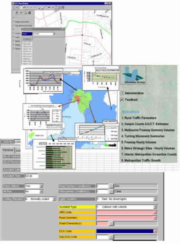
The Road Information Systems group at VicRoads supports the road assets, traffic, and crash data systems. The data collection and data support activities are conducted under contract to the road safety group at VicRoads. Crashes are sent to VicRoads in an electronic format, and the staff performs extensive quality control on these data. The crash system uses GIS and has been developed for Intranet and Internet access (Vic roads website) by all authorized users. Figure 13 shows several examples from this system.
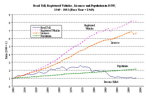
The past 25 years have seen significant improvements in road safety in New South Wales. The road fatality toll has been cut by more than 60 percent while estimated motor vehicle travel has doubled. The fatality rate is now similar to levels in the late 1940s, even though figure 14 shows that the population has doubled since that time. Six times as many licenses have been issued, and eight times as many vehicles are on the roads.
Road traffic accidents totaling 51,814 were recorded in New South Wales during 2001, with 524 persons killed and 29,913 injured. The Roads and Traffic Authority (RTA) estimates the economic cost to the community of these crashes at $2.58 billion.
RTA is the New South Wales government agency responsible for (1) testing and licensing drivers and registering and inspecting vehicles, (2) managing the road network to achieve consistent travel times, (3) improving road safety, and (4) providing road capacity and maintenance solutions.
As stated in Towards 2010, the New South Wales government is committed to ensuring the following:
These goals reflect the partnership between the RTA and the community and the importance of both in ensuring road safety.
Crashes involving vehicles and people (on and off roads) are reported to the New South Wales police and are categorized as either major or minor. Major crashes involve injuries, deaths, intoxication, towed vehicles, and cases in which drivers left the scene or failed to exchange particulars. Minor crashes are all other crashes and are reported at the police station or by telephone to the Police Assistance Line (PAL). In the field, the officer writes particulars about the crash into an official notebook.
Information the officer gathered is then captured in a mainframe system called COPS (Computerized Operational Policing System). This system provides a single access point by storing all policing information in one database. COPS can be accessed either at the police station or via mobile data terminals in police vehicles. Officers enter the majority of the information into COPS, although unsworn staff members perform some data entry.
COPS has an interface with the RTA and National Vehicles of Interest systems to integrate vehicle and personal details, and location coordinates can be entered if a GPS is available to the officer. The officer's narrative summary of the crash is also entered and becomes available to both internal and external customers. Data from COPS is available to both internal and external agencies, such as the RTA and the Bureau of Crime Statistics.
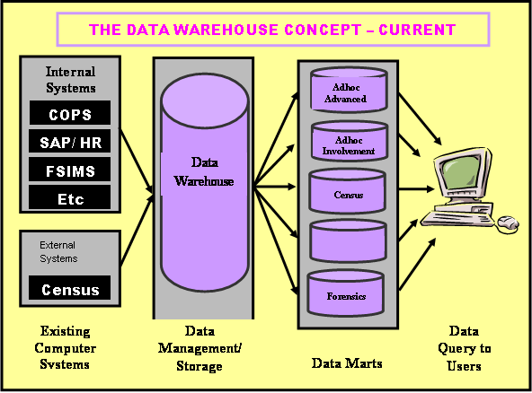
The purpose of COPS is to provide fast and easy access to comprehensive and reliable information about motor vehicle crashes. The main benefit of COPS is the ability to share information. COPS is one of many systems that reside in a data warehouse environment for easy access. This concept is illustrated in figure 15. Crash data can also be exported and downloaded from COPS into various other software packages. The Traffic Research and Intelligence Unit (TRIU) within the RTA downloads data from COPS and uploads that data into Microsoft Access databases for analysis and reporting.
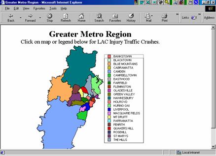
TRIU staff is responsible for developing and maintaining the Traffic Services Branch Intranet site available to all within the New South Wales Police. Fatal information is updated daily for reporting to the Police Executive and Media Unit, and other information is updated on a monthly basis. Statewide traffic operation data are available on a daily basis. Information is available from the data
warehouse in graphic and table format for police and intelligence officers throughout the state, and they can drill down to their local area command (LAC) level by selecting the region or LAC, as shown in figure 16.
|
|
The Crash Analysis Unit developed and maintains a suite of road traffic accident databases. These databases were introduced in Sydney to consolidate information from several stand-alone and networked accident, GIS, and fatal accident databases and applications to form a single database suite for use by the unit and other Sydney Client Services staff.
The Crash Analysis Unit conducts systematic accident investigation studies in Sydney to identify hazardous locations that could be treated under the Regional Accident Blackspot programs. These studies of the Sydney road network are also fundamental in identifying potential locations for the RTA's Fixed Digital Speed Camera Program and in Mass Action investigations covering issues such as right turn filter and red light running collisions. The unit is also responsible for managing, analyzing, and maintaining Sydney road safety data.
| << Previous | Contents | Next >> |