U.S. Department of Transportation
Federal Highway Administration
1200 New Jersey Avenue, SE
Washington, DC 20590
202-366-4000
In Australia, the road reserve includes the land occupied by the road as well as the roadside that extends to the adjacent property lines. The concepts of road reserve and road right-of-way (as applied in the United States) have many similarities. However, the treatment of the road reserve in Australian legislation historically has been stronger and more centralized than the treatment of the right-of-way in the United States, which has implications for the application of practices and strategies related to transportation planning and asset management. Australian states have also benefited from the application of more centralized land use practices as well as high-level planning and land title registration offices that work with ministries of transportation and other state agencies to provide orderly, coordinated land use planning.
In Canada, right-of-way acquisition and management practices tend to be more similar to those in the United States. In both Alberta and Ontario, however, the provincial transportation departments have the power to regulate not just access to the road right-of-way but also development on adjacent land, more specifically by regulating minimum setbacks for buildings and other structures to help preserve corridors in case the road ever needs expansion.
Both Australia and Canada place strong emphasis on preservation of future corridors, as well as on preservation of current corridors for future use.
In New South Wales, all property acquisitions by local councils or state government agencies, including RTA, are governed by the Land Acquisition (Just Terms Compensation) Act 1991 (LAJTCA).(13) In New South Wales, RTA owns freeways and toll roads. The rest of the transportation network is vested in local councils, although RTA is responsible for road maintenance (i.e., from curb to curb) on these corridors. The Sydney region has 40 local councils. The Roads Act 1993(14) enables RTA to acquire property in accordance with LAJTCA provisions.
Properties required for RTA road construction are acquired in the name of the Roads and Traffic Authority of New South Wales on titles registered at the NSW Department of Lands,(15) which is the largest centralized land title registry in Australia. Most land titles in Australia are Torrens titles, which are based on registered plans that define the boundaries of each land parcel. For each land parcel registered, the Department of Lands issues a certificate of title to provide proof of ownership. A very small proportion of land in New South Wales is still owned under the common law deed-based system used before the introduction of the Torrens system in 1863. The department is converting those remaining parcels to the Torrens system.
LAJTCA encourages acquisition by negotiated purchase, similar to buying a property on the open market, rather than by compulsory acquisition. For RTA-initiated acquisitions, RTA prepares a letter advising property owners that a valuer representing RTA will value their property for the purpose of submitting a formal offer for the owners' consideration.(16) The letter also invites property owners to submit an asking price and specifies the maximum amount that RTA will reimburse property owners if they engage the services of registered valuers (i.e., registered appraisers).
Despite the additional cost, RTA has found the practice of engaging registered valuers effective in facilitating the acquisition process. In general, after the RTA appraiser prepares an evaluation report, RTA submits an offer to the property owner. If the property owner asks for a copy of the evaluation report, RTA indicates its willingness to exchange evaluation reports. This practice further encourages property owners to engage the services of registered valuers.
Before March 2006, the NSW Department of Planning acquired vacant land reserved for county roads and held that land until it was transferred to RTA at the time of construction. The process under LAJTCA is different. Owners of land or improved property reserved for county roads can have their property acquired ahead of road construction only if the owners can demonstrate that hardship conditions apply. For RTA-initiated acquisitions, RTA typically starts the purchase of land when the project enters the design phase.
Frequently, corridor preservation strategies are not feasible because of the high costs associated with rightof- way acquisitions. In the Sydney area, only about 50 percent of a typical project budget actually goes to the road itself, 20 to 30 percent of the total budget goes to right-of-way acquisition, and the remaining percentage goes to utility relocation. RTA engages registered valuers early in the project development process to develop preliminary property acquisition cost estimates.
RTA frequently signs lease agreements with property owners while the acquisition process continues to provide early right of entry to the property and reduce delay in construction timing. In practice, most owners do not negotiate the rental fee and simply accept what RTA proposes.
While negotiations with an owner take place, RTA develops a parallel compulsory acquisition time line to make sure the land is acquired by the anticipated road construction contract date. Compulsory acquisition follows a well-established protocol that includes publication in the NSW Government Gazette, a valuation by the NSW Office of the Valuer General, and other steps to ensure compliance with LAJTCA. (The Office of the Valuer General, under the Department of Lands, has statutory responsibility for providing land valuations for rating and taxing purposes, as well as determining compensation following compulsory acquisition.(17,18) Related Department of Lands offices are the Office of the Surveyor General, responsible for official surveying and cadastral and topographic mapping, and the Office of the Registrar General, responsible for registration of plans and land titles.) Gazettal of compulsory acquisition gives legal title to RTA (therefore converting the former owner's interest in the land to an entitlement to compensation), but not possession. Possession takes place after LAJTCA processes have been completed, usually about 120 days after gazettal. In general, property owners have 90 days to accept the amount of compensation or file an objection with the NSW Land and Environment Court.
Under the Transport Planning and Coordination Act 1994,(19) Main Roads has the power to acquire land for transportation infrastructure purposes. Other enabling pieces of legislation include the Transport Infrastructure Act 1994,(20) the Integrated Planning Act 1997,(21) the Land Act 1994,(22) and the Acquisition of Land Act 1967.(23) The Transport Infrastructure Act 1994 enables Main Roads to, among other functions, declare statecontrolled roads, regulate other parties that wish to conduct construction work or otherwise interfere with state-controlled roads, and manage access of utility facilities within those roads.
In Queensland, the Department of Natural Resources, Mines, and Water administers all state land and acts as owner of the land. Following the Land Act 1994, the department vests dedicated roads (by gazettal) to local governments, although dedicated roads may also be declared state-controlled roads by Main Roads.
The property acquisition process is similar to other Australian states. Consultation with landowners starts early once the preferred route is identified. Main Roads officials attend community consultation with project engineers to identify and overcome issues that may delay the property acquisition process. Main Roads acquires land either through a "voluntary purchase" or through a "resumption" process. Main Roads uses the voluntary purchase option for early acquisitions of property, mainly in cases of owner hardship or when it is advantageous to the state (e.g., for corridor preservation purposes). The resumption process includes serving a "Notice of Intention to Resume" to property owners and executing a series of steps that end with the land becoming the property of the Crown (which takes place after an appropriate notice is published in the Government Gazette), the interest of the owner becoming a right to claim compensation, and the previous owner receiving compensation.
In general, the compensation basis is an independent valuation of the property's market value that Main Roads obtains at the date of gazette (although Main Roads reimburses property owners reasonable fees for the services of registered valuers and legal counsel). Main Roads also has the ability to issue an advance payment against compensation. Main Roads also includes allowances for costs such as relocation costs, redirection and reconnection of utility services, and costs associated with the purchase of replacement property (such as conveyance, surveying, and building inspection). Main Roads does not reimburse for the services of consultants that help the property owner object to a project.
Main Roads does not have the ability to use incentives (only market value and items such as disturbance are allowed) or "solatium" (i.e., the determination of intangible and any nonmonetary disadvantages resulting from the acquisition, which is common in other Australian states). Recently Main Roads attempted to change the Acquisition of Land Act 1967 to allow for solatium, but was unsuccessful.
Main Roads' Property Services office acquires all property required for road purposes throughout Queensland. In this capacity, the Property Services office acquires land on behalf of agencies such as Queensland Transport, TransLink, Brisbane City Council, and Airport Link and Northern Busway.
The Highways Act 1926 gives DTEI the authority to acquire property needed for road projects.(24,25) The act also enables DTEI to acquire land in excess of the requirement as the commissioner of highways deems expedient and as approved by the minister. The Land Acquisition Act 1969 contains provisions for the acquisition of property, including compulsory acquisition.(26) In general, DTEI prefers negotiated purchases to compulsory acquisitions.
Acquisition by negotiated purchase can occur during early planning phases or after an approved alignment has been announced. As figure 10 (see next page) shows, during the early planning phases of a project, DTEI may agree to a property purchase when property owners have difficulty selling their property in the open market. In practice, DTEI has a large number of properties it acquires and needs to manage and maintain for a long time in anticipation of future transportation projects.
A tool for corridor preservation in South Australia is the Metropolitan Adelaide Road Widening Plan Act 1972.(27) This act requires the commissioner of highways to prepare a plan called the Metropolitan Adelaide Road Widening Plan (which identifies corridors for future transportation expansion and may be subject to revision from time to time) and to file this plan with the Registrar General of Deeds in the General Registry Office. The act also gives the commissioner the power to approve certain types of building work on the land shown on the plan as possibly required for road expansion and all land within 6 meters (m) (about 20 feet (ft)) of the boundary of that land. All real estate transactions on those corridors have a note on the title certificate about the future use of the corridor.
One provision in the Land Acquisition Act 1969 is that it is necessary to give a notice of intention to acquire land to each person whose interest in the land is subject to acquisition. To this effect, DTEI asks the registered owner of a property to identify anyone else who has an interest in the property but whose name does not appear on the title certificate (e.g., a lessee, an equitable owner, a holder of an encumbrance or a lien, a mortgagee, or a business operator). Each party must be compensated individually. Part of the process of interacting with each property interest holder is taking into consideration the need to preserve basic services to the community. As an illustration, DTEI officials mentioned the case of a surgeon's practice, in which DTEI made sure the surgeon's offices were completely relocated over a weekend to ensure the surgeon's ability to see patients at the new location on Monday morning. Each affected party is entitled to engage an appraiser to provide a valuation. DTEI reimburses reasonable costs of obtaining the independent advice. DTEI advises appraisers to discuss their proposed charges with DTEI before carrying out the valuation. Accompanying the notice of intention is a request that the parties grant DTEI the right to enter the property to conduct preliminary activities such as surveying, soil testing, and evaluation of utility facilities.
DTEI's compulsory acquisition process can take months to years, depending on the situation and whether the standard or accelerated process is followed. With the standard process, it can take about 14 months for DTEI to obtain the right of entry to the property (negotiations on compensation can continue until settlement). With the accelerated process, the parties agree to waive the right for detailed information about the project and the right to object to the acquisition, which can result in the property owner granting DTEI right of entry to the property in about 6 weeks. In addition, settlement and compensation can occur in less than 6 months.
DTEI has also implemented a number of acquisition incentives, including the following:
Click image to enlarge.
Figure 10. DTEI's property acquisition process by negotiated purchase.(24)
In Victoria, two critical pieces of legislation are the Road Management Act 2004 (28,29) and the Land Acquisition and Compensation Act 1986.(30) The Road Management Act 2004 established a new statutory framework for managing the road network that took into consideration various road reserve uses, including roadways, pathways, and other types of infrastructure. The act outlined rights and duties of road users; defined roles, functions, and powers of a road authority; required development of codes of practice to provide practical guidance on road management; and provided a new process for declaring and classifying roads and reallocating management responsibility for roads.
The Land Acquisition and Compensation Act 1986 established a framework for acquiring land by authorities that, through special acts, have acquisition powers. VicRoads and utilities are "authorities" and can acquire interests in property. Through acts of parliament, privately held utilities have similar powers. In general, for land acquisition to occur, the land must be reserved for a public purpose. Project-specific legislation has also provided a short-cut process that facilitates development of a project framework in situations in which several local jurisdictions and agencies are involved and it is important to outline the roles, rights, and responsibilities of each. VicRoads has used this mechanism to facilitate development of projects such as the EastLink Project and the Melbourne CityLink Project.(28) Lands in Victoria are registered with the Registrar of Titles.(31) This office records property ownership changes, mortgages, property transactions, and new subdivisions.
The Road Management Act 2004 mandated the establishment of codes of practice to provide practical guidance on road management. The following codes of practice have been developed through a process of public consultation:(29)
One provision in the Land Acquisition and Compensation Act 1986 is the need (with some exceptions) to give a notice of intention to acquire land to each person whose interest in the land is subject to acquisition. The act also requires filing the notice of intention with the Registrar of Titles. In turn, the Registrar of Titles must make a recording of the notice in the register and make the notice of intention available for inspection.
Serving the notice of intention to acquire property and registering the notice with the Registrar of Titles enables the coordinating road authority to control any type of development that might negatively affect that authority's ability to acquire the property. For example, any agency processing planning permits or building permits that relate to land on which a notice of intention to acquire has been served must forward a copy of the application to the coordinating road authority. Likewise, the road authority has the capability to consent to any transaction or improvement affecting the property in question (in fact, the Registrar of Titles must notify the road authority of any documents filed that pertain to that property).
Although road reserves are identified early in the planning process using public acquisition overlays, there is no legislation locking the land use. As a result, when VicRoads acquires property, it needs to do so at the conditions prevalent at the time of purchase. If the property owner is the same from the original public acquisition overlay, a provision allows compensation for the loss of the ability to develop the land. Victoria does not have laws in place requiring compensation for impacts caused by highway projects to property not acquired, such as noise, business interruption, access denial, and construction inconvenience. In addition, VicRoads does not use incentives other than the acquisition price (and compensation for professional representation). The only mechanism to provide more compensation (up to 10 percent of market value) is solatium (i.e., the determination of intangible and any nonmonetary disadvantages resulting from the acquisition).
In Victoria, when the market value of the land or the combined value of two or more properties, parcels, allotments, or titles is less than Au$250,000, it is mandatory to obtain one valuation, which could be from the Valuer General or a valuer who is a member of the Valuer General Valuation Services Panel.(32,33) If the value is between Au$250,000 and Au$500,000, a valuation from the Valuer General is mandatory. A second valuation, which is optional, must be from a valuer who is a member of the Valuer General Valuation Services Panel. If the value is greater than Au$500,000, two valuations are mandatory, one from the Valuer General and a second from a valuer who belongs to the Valuer General Valuation Services Panel. A second valuation is not mandatory when the transaction involves another state agency.
On a project-by-project basis, VicRoads used to purchase property with suitable habitats to replace losses resulting from projects (i.e., lose x and replace with x). Now, VicRoads has expanded the practice to include replacing x with x + y. Compulsory acquisition does not apply to this type of property acquisition.
The Expropriation Act(34) covers the acquisition of private land for public works in Alberta, except in the case of acquisitions made by the federal government. The act sets out principles and procedures, including owner objection and appeal rights, as well as the determination of fair compensation, which includes both property market value and damages. The act also recognizes the owner's right to obtain (and receive compensation for reasonable costs related to) independent legal, appraisal, and other professional advice throughout the acquisition process. Alberta Transportation does not use signing bonuses or other incentives, but it has some flexibility on damage identification.
In addition, Alberta Transportation has established a minimum agreement value of Can$500, which is used for small partial purchases, such as corner cutoffs for intersection improvements. Land exchanges occur at the request of the landowner when and if an equitable parcel is available. Leasebacks may also be considered as part of the negotiation for a preferred or nominal compensation rate for demonstrated losses related to the sale. When only a partial purchase is necessary, it is possible to acquire a larger portion or even the entire parcel if a landowner requests it and appropriate justification exists.
Before any expropriation starts, an attempt must be made to acquire the property through negotiation. If negotiations break down but the only obstacle to entering into a voluntary agreement is market value compensation, Alberta Transportation offers the property owner the opportunity to enter into a voluntary expropriation under Section 30 of the Expropriation Act, which gives the landowner the right to make a further claim for compensation before the Land Compensation Board. At this point, the department gains possession of the land and the project can proceed. If these negotiations do not resolve the landowner's issues, the department considers an involuntary expropriation under Section 8 of the Expropriation Act. A minimum of 9 months is normally required to secure right-of-way when using a Section 8 expropriation.
In the case of roads on public lands (60 percent of the land in the province is Crown land), it is necessary to request a provisional roadway reservation from Alberta Sustainable Resource Development (ASRD), the agency responsible for managing all public lands in the province.
The acquisition of property for highway projects actually starts with project identification through a regional priority list and the results of a functional planning study, which includes meetings with and feedback from landowners. Once the project is selected, an independent appraiser is contracted to perform a project appraisal to determine the market value of the lands in the project.
One problem with the traditional approach to project selection is that some projects either never make it to the priority list or take a long time to be included. To address this limitation, Alberta Transportation is developing a new project selection process that involves the use of various asset management systems to project future highway, pavement, and bridge asset conditions. Through technical and safety ratings, projects will be identified for assignment to preliminary engineering and scope of work well in advance of construction. High-risk projects will be identified for further consideration to ensure high-risk items are addressed as early as possible. With this new approach, Alberta Transportation will be able to start acquiring land for projects when the planning process is finished (i.e., well in advance of the design phase).
Alberta Transportation has experimented with a variety of property-related approaches to environmental mitigation, including the following:
In the case of acquisition of parcels containing contaminated or hazardous materials, Alberta Transportation attempts to gather as much information as possible during the project development phase. On occasion, it is possible to change the road alignment to avoid contaminated sites. In other cases, the task is to determine the most effective strategy to address the contamination, including remediation before construction, remediation during construction, and risk management. Environmental impacts related to utility relocations are rarely considered during the project development phase. In general, the policy is that utility companies are responsible for addressing any environmental issues that arise on the relocation of their facilities.
Under the Highways Development and Protection Act,(35) Alberta Transportation has the power to regulate access to the road right-of-way as well as development on adjacent land. One reason for this power is so Alberta Transportation can regulate building setbacks if the road ever needs expansion, preventing the agency from having to pay for unnecessary costly improvements. The extent of the land under regulation varies depending on the road type. For example, according to a regulation now under development, the extent of land under regulation will be 150 m (492 ft) from the right-of-way line for minor provincial highways and 300 m (984 ft) from the right-ofway line for multilane provincial highways.(36)
The Government Organization Act(37) enabled the establishment of restricted development areas (RDAs) to coordinate and regulate the development and use of certain areas in Alberta. The Calgary RDA(38) and the Edmonton RDA(39) are of particular interest because of the designation of TUCs within those RDAs.(40) Figure 11 shows the Calgary TUC and figure 12 (see below) shows the Edmonton TUC.
Figure 13 (see below) shows a typical TUC cross section, which illustrates some of the various land uses recognized by the regulation, including the following:
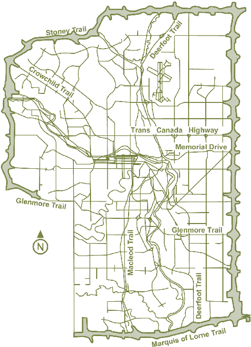
Figure 11. Calgary TUC.(40)
Courtesy of Alberta Infrastructure
Note: The TUC is the outer corridor between the thick right-of-way lines. The southwest TUC right-of-way is incomplete because of pending negotiations with a local tribe.
The RDA regulations require ministerial consent to allow any surface disturbance within the RDA boundaries. A restricted development area caveat is also placed on each title within the boundaries of the TUC, regardless of whether the land is privately or publicly owned (most of the land within the TUCs is provincial Crown land). Road allowances and road plans within the TUC, which lie under the jurisdiction of Calgary or Edmonton, are similarly bound by the regulations. The regulations also prevent any other provincial government department or quasigovernmental organization from issuing approvals for disturbances within the TUC without prior consent.
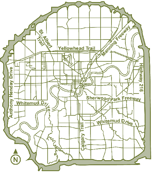
Figure 12. Edmonton TUC.(40)
(Courtesy of Alberta Infrastructure)
Note: The TUC is the outer corridor between the thick right-of-way lines.
Two important pieces of legislation in Ontario are the Public Transportation and Highway Improvement Act(42) and the Expropriations Act.(43) Following the Expropriations Act, allowable compensation to an owner includes the current market value of the land (i.e., without including any change in value resulting from the development or imminence of development), damages attributable to disturbance, damages for injurious affection (i.e., impact on neighboring land as a result of the project), any special relocation difficulties, and business losses. Business losses are not determined until the business has moved and been in operation for 6 months or until a 3-year period has elapsed, whichever occurs first. MTO also reimburses for reasonable costs, including appraisal, engineering reports, and planning reports. MTO estimates the total impact of these fees at about 15 percent of the total cost of the property.
Click image to enlarge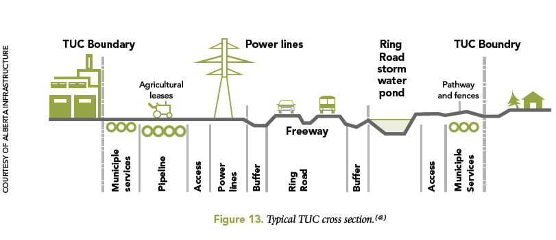
Figure 13. Typical TUC cross section.(41)
MTO is beginning to experiment with various incentives to encourage property owners to complete the acquisition process quickly, such as the following:(44)
Along with the offer, MTO shares the appraisal report with the property owner. For high-value properties, MTO uses two or more appraisals. Appraisers are not involved in the negotiations. All appraisers are fee appraisers. In general, MTO serves notifications to each individual or party with an interest in a property.
Although MTO acquires most properties after the planning or preliminary design phase is completed to ensure certainty on which properties are affected, MTO can make advance purchases in owner hardship situations (in this case the owner typically initiates the transaction) or if the need is critical (in this case MTO typically initiates the transaction). In general, the expropriation tool is not available to MTO until the environmental process has ended.
MTO acquires property either by deed (i.e., amicably, which is the preferred approach) or by expropriation. Purchases by deed can take from 1 day to 9 months, depending on the nature of the property being acquired. Expropriations can take an additional 7 to 10 months. When an owner consents to the acquisition but not to the price, MTO purchases the property by deed at the price that MTO has offered. The former owner then has the right to appear before the Ontario Municipal Board to claim additional compensation within a 2-year period.
Under the Planning Act,(45) MTO has the power to regulate access to the road right-of-way (i.e., land dedicated to roadway purposes) and development on adjacent land. As in Alberta, this power enables MTO to regulate building setbacks and utility installations in case the road ever needs expansion, preventing MTO from having to pay for unnecessary costly improvements. Regulation tools at MTO's disposal cover encroachments and utility installations, buildings and land use, signs, and highway access. The minimum setback for new buildings or other structures depends on the road type and proposed development. On controlled-access highways, for example, the control area within which all development is subject to permit requirements from the ministry is 45 m (148 ft) from the right-of-way. This permit area extends up to 395 m (1,296 ft) at interchanges. Detailed information about setback requirements and specific regulatory procedures is included in the MTO Corridor Control and Permit Procedures Manual.(46)
In New South Wales, RTA holds about 51,000 parcels of land in its Property Information Management System (PIMS). RTA is in the process of migrating this system to a GIS-based architecture. Property required for RTA road construction is acquired in the name of the Roads and Traffic Authority of New South Wales on titles registered at the NSW Department of Lands,(15) the largest centralized land title registry in Australia. Most land titles in Australia are Torrens titles, which are based on registered plans that define the boundaries of each land parcel. For each land parcel registered, the Department of Lands issues a certificate of title to provide proof of ownership. A very small proportion of land in New South Wales is still owned under the common law deed-based system used before the introduction of the Torrens system in 1863. The department is converting those remaining parcels to the Torrens system.
In Queensland, Main Roads holds about 3,100 properties for future infrastructure projects, of which 1,000 properties are now rented. Main Roads is responsible for any property taxes on those properties. In some cases, the rent collected does not match the amount of property tax paid. However, clearing the land ahead of the transportation project is not always feasible because it would prevent neighbors from objecting to the transportation project. Main Roads owns a limited number of billboards. However, the agency does not normally rent billboards because of traffic safety considerations.
Although not related to property management, an electronic Development Application Management (eDAM) application is under development at Main Roads as a mechanism to automate the permitting process for urban developments. eDAM will receive development applications through a Web-based application (called Smart eDA) that the Department of Planning and Infrastructure developed to help the referral and permitting process in the state (the land development process now involves up to14 agencies). The driving force behind Smart eDA and eDAM is the need to eliminate paperwork, facilitate communications between applicants and managers, and standardize the submission process. Main Roads is including a GIS interface. The interface includes dates such as date received and due date, which are state mandated. It also includes forms and supporting documentation. For electronic upload of documents, eDAM will rely on Smart eDA, which encourages applicants to submit files in PDF format (although the protocol also supports sending documentation by regular mail).
Main Roads has about Au$23 million in excess property. According to the Acquisition of Land Act 1967, if resumed property is no longer required for road purposes in 7 years, Main Roads must offer it back to the former owner at market value. If this is not feasible, Main Roads first offers the property to other government agencies (at market value) and then, if needed, sells the property by public auction or tender. In certain circumstances, it is possible to bypass the public auction requirement (e.g., in cases in which the property is of use only to an adjoining owner, a purchaser offers a premium price related to the intended use of the land, or special environmental, planning, or economic reasons exist).
In South Australia, DTEI has a GIS application that depicts the location and potential land affected by future corridors. In Victoria, VicRoads uses several systems to manage properties, including the GIS-based VISTA system. VISTA shows parcels being acquired in different colors as the acquisition process moves along, as well as properties VicRoads has had for a long time (figure 14). Parcel features in the system are time stamped and can be queried, which enables VicRoads to examine and overlay the history of parcel acquisitions going back to previous owners. The system also shows survey plans.
Click image to enlarge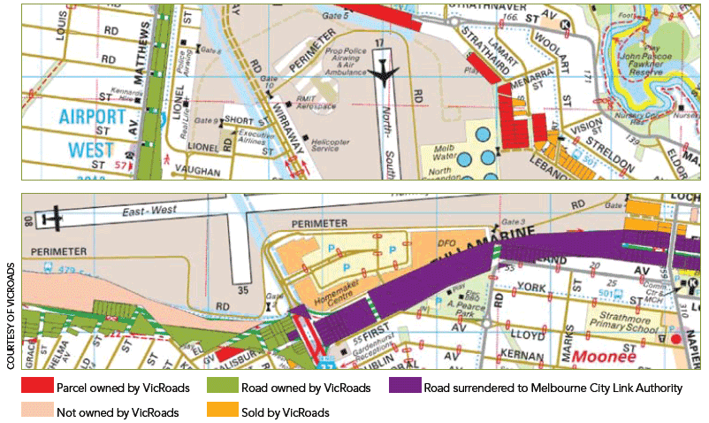
![]()
Figure 14. VicRoads GIS representation of parcels.
(Courtesy of VicRoads)
For faster rendering on user interfaces, the background layer is an image mashup that includes a number of layers of interest, such as roads, rivers, landmarks, and general parcel boundaries from the Registrar of Titles. VicRoads has also scanned all of the titles the agency had ever acquired.
The use of georeferenced data starts early with the identification of the road reserve (and corresponding registration with the Registrar of Titles) and the production during the planning process of public acquisition overlays that illustrate the extent of the road reserve in relation to existing parcels in the general vicinity of the project (figure 15).
In Victoria, VicRoads' property services office manages leases, licenses, and property sales. Victorian law requires property sales to be at market value, even among public agencies, although on occasion a property needs to be released at a lower value (e.g., because of zoning considerations). In general, VicRoads prefers licenses to leases because leases involve some assumption of exclusivity. On occasion, VicRoads receives requests to lease small sections of property, particularly from telecommunication providers. VicRoads' preference is to lease entire properties. Leases and licenses are also executed at market value. Revenue from leases goes to the general fund. VicRoads inspects residential properties every 6 months and other properties every year. In general, VicRoads owns property in fee simple, including the air space.
Victoria's Department of Sustainability and Environment is developing a GIS-based system that will show all government-owned properties. This system will enable government agencies to view what properties Victoria owns.
In Alberta, Alberta Infrastructure maintains a system called the Building and Land Inventory Management System (BLIMS), which records lands leased by or titled to the department. Examples of data captured in this system include location, legal description, acreage, improvements, sale or purchase price, ongoing rights or obligations associated with the land, leases, and acquisition or surplus file numbers. Alberta Infrastructure also uses a Web-based mapping application that identifies properties owned or leased by the agency. Alberta Transportation maintains a land automated information system (LAIS), which keeps track of inventory and status of properties acquired for Alberta Transportation projects.
Alberta Infrastructure's Realty Services manages marketable excess properties from Alberta Transportation and other government departments. Realty Services first circulates properties identified as potentially surplus among province agencies. If no agency is interested, Realty Services requests that the minister of infrastructure declare the land surplus and reviews the property's suitability for affordable housing. If suitable, the property is placed on Alberta Municipal Affairs' affordable housing inventory list. If not suitable, Realty Services offers the property at its appraised value to the municipality where the property is located. If the municipality proposes to use the property in a manner that benefits two or more municipalities, it is possible to sell the land for a nominal sum if approved by the Treasury Board. If the municipality intends to use the property for redevelopment or resale, it must compete with any other interested purchasers through the multiple listing system process. If the municipality declines, Realty Services sells the property on the open market.
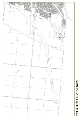
Figure 15. Sample public acquisition overlay showing proposed road reserve.
Service Alberta is responsible for maintaining land titles and surface and mineral rights in the province. The agency developed a system called the Spatial Information System (SPIN 2), which keeps track of land title data products, registered survey plans, township images, survey control markers, and soil capability information. BLIMS uses updated information from SPIN 2.
In Ontario, the Ontario Realty Corporation (which reports to the Ministry of Public Infrastructure Renewal) manages the province's real estate portfolio. In general, ministries can dispose of excess property if no other provincial government agency needs the land. The province has a goal of selling properties at fair market value. It is possible to sell at less than fair market value, but in this case, the agency responsible for the property must pay the difference between the selling price and the estimated market value.
MTO has 7,100 properties in its database, of which 450 properties province wide are leased. MTO also has a cell tower lease program that allows cell towers to be located in the right-of-way. Accommodation of these facilities is by legal agreement, not by permit.
| << Previous | Contents | Next >> |

